- Artists transform hurricane aftermath into hoop-inspired masterpieces at Charlotte exhibit
- NC's cost for Hurricane Helene damage is nearly $60 billion, state says
- State to develop drone program to better respond to disasters like Helene, Florence
- South Carolina residents face deadline to get storm debris out to the curb after Hurricane Helene
- SCDOT to pick up Hurricane Helene debris for a final day in South Carolina
Bertha Brings Heavy Rain, Possible Flash Flooding

TROPICAL UPDATE#Bertha has weakended to a tropical depression with sustained winds of 35mph. The main threat in central North Carolina will be heavy rain tonight. However, we still cannot rule out the possibility of an isolated tornado. #ncwx pic.twitter.com/ouKlwlkVDk
— Robert Johnson (@RobJohnsonABC11) May 27, 2020
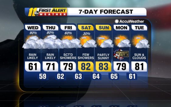
Bertha will affect central North Carolina tonight with most of the showers and storms residing in the Sandhills and areas west of the Triangle. Heavy rain and flash flooding will be the main threat. However, there is the potential for an isolated tornado.
We’ll continue to see scattered showers and storms Thursday through Saturday, some of those storms could turn severe.
A cold front swings through on Saturday night and will allow for a cooler and more comfortable airmass on Sunday. Sunshine will finally make a welcome, lasting return beginning Sunday afternoon and will extend at least through Wednesday.
Be Well & Stay Safe!
Robert Johnson
Check the radar anytime with the free AccuWeather app for iPhone and Android today!
Copyright © 2020 WTVD-TV. All Rights Reserved.