- National memorial to honor NC firefighter who died on duty during Hurricane Helene
- Gov. Josh Stein extends State of Emergency for western NC wildfires
- Governor Stein extends state of emergency for NC wildfire threat
- Governor Stein extends emergency in 34 NC counties amid wildfire threat
- Texans can buy emergency preparation supplies tax-free April 26-28 ahead of severe weather season
Tornado warning issued for eastern Sampson County until 6:15 p.m.
A tornado warning has been issued for eastern Sampson County until 6:15 p.m.
WRAL meteorologist Kat Campbell said rotation is being seen in a strong storm system just east of Clinton, west of Warsaw and south of Turkey. It is moving north-northeast at 5 mph. The system is producing heavy rain and strong winds with lots of lightning. Some hail is also possible.
Parts of the Triangle westward will continue to be under a level 1 risk for severe weather for the rest of the day Thursday.
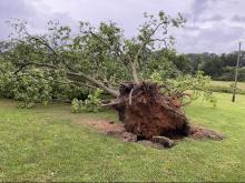
The entire state has a chance of thunderstorms. Durham, Orange, Chatham, Moore, Lee, Person and Granville counties could see the most damaging rain and wind gusts. The storms Thursday and Friday won’t be as powerful as what residents saw Wednesday, when there were two tornado warnings, including an EF-0 tornado that touched down in Warren County.
Halifax County has a flood warning in place until further notice. On Friday, the Lower Roanoke River near Scotland neck is expected to rise above flood stage at midnight and rise near 30 feet by Sunday morning. If the river reaches 31 feet high, then there is widespread flooding on the bank, according to the National Weather Service.

First thing Friday morning there will be waves of rain rolling through. The threat for rain and storms decreases in the Triangle, though Person, Granville and Vance counties will be under a level 1 risk.
Both Friday and Saturday will be hot and humid, with highs in the low 80s and scattered showers.

Sunday will be dry, less humid and pleasant, with a high in the upper 70s.