- Seven months after Hurricane Helene, Chimney Rock rebuilds with resilience
- Wildfire in New Jersey Pine Barrens expected to grow before it’s contained, officials say
- Storm damage forces recovery efforts in Lancaster, Chester counties
- Evacuation orders lifted as fast-moving New Jersey wildfire burns
- Heartbreak for NC resident as wildfire reduces lifetime home to ashes
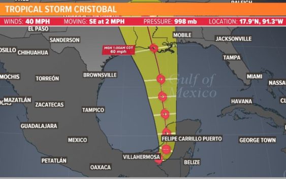
Tropical Storm Cristobal's US landfall expected in Louisiana

The storm’s forecast cone continues on a northern track towards Louisiana, but Texas is not totally in the clear yet.
HOUSTON — Tropical Storm Cristobal formed in the Gulf of Mexico on Tuesday and is forecast to make landfall as a storm along the Louisiana coast early next week.
But Texas isn’t totally in the clear yet.
This week was the official kick off to the 2020 Atlantic hurricane season, and it’s already turning out to be busy. We already had Arthur and Bertha form in the second half of May.
Cristobal is the earliest we have had the third named storm form on record, and records go back to 1851.
Where will Tropical Storm Cristobal go?
The official forecast track from the Hurricane Center takes the storm north across the central Gulf of Mexico, toward the upper Texas or Louisiana coast on Sunday afternoon.
How Strong?
Intensity forecast are always the most challenging part of tropical cyclone forecasting. Cristobal is currently interacting with the land mass of southern Mexico which is keeping it weak for now.
June cyclones are usually very weak and disorganized systems — still being sheared apart from the westerlies as the seasons continue to transition into Summer. However all systems are different.
Seen in the white box above is the Gulf of Mexico. If you look carefully there are a bunch of red lines crossing the gulf from Mexico to Florida. That’s an indication that the wind shear is very strong over the gulf which could help keep this system from developing into a full blown hurricane.
The current thinking is anything that would develop would on the weaker side of things with a tropical storm the most likely outcome. Of course models show a wide range of possibilities so it’s important to keep watching.