- National memorial to honor NC firefighter who died on duty during Hurricane Helene
- Gov. Josh Stein extends State of Emergency for western NC wildfires
- Governor Stein extends state of emergency for NC wildfire threat
- Governor Stein extends emergency in 34 NC counties amid wildfire threat
- Texans can buy emergency preparation supplies tax-free April 26-28 ahead of severe weather season
As rain persists, flooding potential greatest east of Triangle
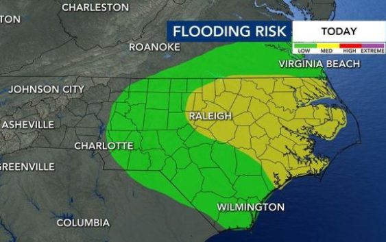
Localized flooding is possible Tuesday as heavy, scattered rain showers move slowly through the region.
Isolated flooding is possible throughout central North Carolina, but counties east of the Triangle are most at risk. Like Monday, rain could fall on and off all day, and downpours are possible at anytime.
For a second straight day, temperatures won’t get out of the 60s. Conditions will also be breezy Tuesday, with winds from the northeast up to 30 mph.
Track rain with the DualDoppler5000.
The rain isn’t going anywhere soon. A chance of rain is in the forecast each day through Sunday, and temperatures will be well below normal until the weekend.

According to WRAL meteorologist Peta Sheerwood, the intensity of the rain will decrease throughout the week, and we should see some sunshine by Thursday.

Cooler temperatures should last for the next few days, though Wednesday and Thursday will be warmer, with highs in the mid 70s.
On Friday, temperatures bump up to normal again, with a high of 85 degrees. Again, rain and thunderstorms are possible.
The weekend should be mostly clear but hot, with highs in the upper 80s or lower 90s. There is a lesser chance for thunderstorms each day.