- Sellers and Rantanen are among the NHL trade deadline winners. Hurricanes and Boeser are some losers
- Hurricane forecasters express concern over NOAA job cuts impact
- FEMA deadline for Hurricane Helene recovery aid extended again
- Tornado drills to take place at schools across North Carolina Friday morning
- Hays County emergency alerts cause confusion during Tuesday's wildfires
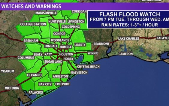
Flash Flood Watch goes into effect from tonight through tomorrow morning
High water spots will be a concern today and tomorrow.
HOUSTON — Get ready for more rain across the Houston area. And now a flash flood watch has been issued.
The flash flood watch goes into effect tonight at 7 p.m. and runs through tomorrow morning at 7 a.m. Included in the watch are the following counties: San Jacinto, Polk, Washington, Grimes, Montgomery, Liberty, Colorado, Waller, Harris, Chambers, Wharton, Fort Bend, Matagorda, Brazoria and Galveston
An upper level disturbance moving that moved here from North Texas is increasing the storm threat. Expect rounds of rain over the next couple of days.
Localized street flooding will be the biggest threat, yet again.
GET ALERTS ON YOUR PHONE: Download the KHOU 11 app
TRACK THE WEATHER: Houston weather radar
The chance for scattered storms and downpours continues the entire workweek ahead of Saharan dust. The storm potential will diminish as we head into the end of the work week, and into the weekend, when the dust should entering the Houston area. Get ready to see some amazing sunrises and sunset but don’t be surprised if a few showers linger into the weekend.
The good news is the dust, which is over the Atlantic for now, has helped keep the tropics calm, so no hurricanes and tropical storms anywhere in sight, likely for the rest of this month.