- Sellers and Rantanen are among the NHL trade deadline winners. Hurricanes and Boeser are some losers
- Hurricane forecasters express concern over NOAA job cuts impact
- FEMA deadline for Hurricane Helene recovery aid extended again
- Tornado drills to take place at schools across North Carolina Friday morning
- Hays County emergency alerts cause confusion during Tuesday's wildfires
Tropical Storm Fay Moves North But Sets Record
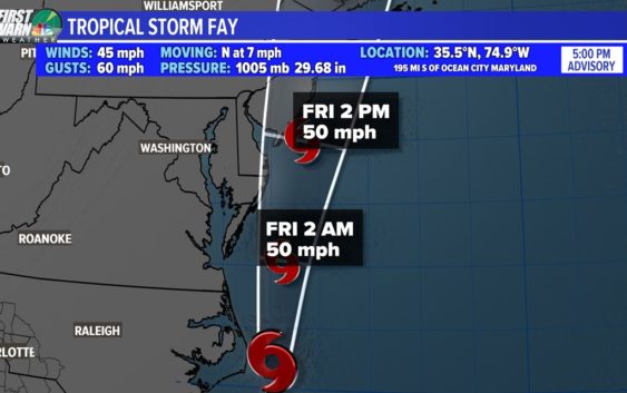
The offshore storm is the 6th named storm of the 2020 hurricane season.
CHARLOTTE, N.C. — Tropical Storm Fay has formed off the North Carolina coast, the National Hurricane Center said as of 5 p.m. Thursday.
The tropical disturbance gained better organization around its center of circulation throughout Thursday. The organization was needed to determine whether the National Weather Service would classify the offshore system as a tropical depression or a tropical storm.
The center is still predicted to track north-northeast hugging the Atlantic coast through Friday night. Landfall in the northern New Jersey and western Long Island looks likely by Friday evening. Winds will weaken as it drives north through cooler waters.
This will not be a long-lived storm but it still made the history books.
Weak But Historic:
Tropical Storm Fay is the earliest, 6th named storm to ever occur in the Atlantic basin. The only other “F” named tropical storm we have had in
July was back in 2005. (NOTE: 2005 was the most active hurricane season on record and the only year we had to move onto the Greek alphabet to name storms later in the season.) Tropical storm Franklin was named on July 21st, 2005 and had peak winds up to 70 mph. Even though Fay will be weaker in strength, it would beat 2005’s 6th named storm by about a week and a half.
The Threats:
The main threats with Fay will be heavy rain along the coast and strong gusty winds. New York City, Long Island and the Jersey Shore are now all under a Tropical Storm Warning for tomorrow. The peak sustained winds will likely level out around 40-50 mph but gusts to 60 mph are possible.
But heavy rainfall could promote some flash flooding. This will be the main threat for areas such as Delaware and Southern New Jersey (Upwards to 2-5+ inches is possible.. This area around the Potomac, Mid-Atlantic, and New England through will all have a moderate chance for flooding rains.
This same low-pressure system is responsible for the clouds and rain seen across both North Carolina and South Carolina earlier this week. The low had tracked across Georgia and the Carolinas before intensifying after entering the Atlantic Ocean off the Southeast coast.
The hurricane season, which historically peaks in September, continues through November annually.