- One set of evacuation orders lifted in Caldwell County after wildfire contained
- 'We gutted every building' | Chimney Rock rebuilding after Hurricane Helene
- 'We gutted every building' | Chimney Rock rebuilding after Hurricane Helene
- Debris from Hurricane Helene provides fuel, complicates containment for spring wildfires
- David & Nicole Tepper increase Hurricane Helene relief commitment to $750k
Tropics update: Tropical Storm Watch in effect from Galveston County down to Willacy County

Tropical Depression Eight is in the Gulf of Mexico and will bring heavy rain to Texas; Tropical Storm Gonzalo is in the Atlantic.
HOUSTON — We are tracking a couple of tropical disturbances: one in the Gulf of Mexico (Tropical Depression Eight) and another in the Atlantic (Tropical Storm Gonzalo).
Get the updates on each below.
Tropical Depression Eight
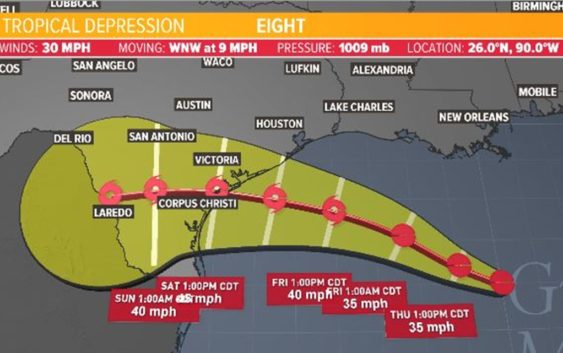
A Tropical Storm Watch is now in effect from High Island (Galveston County) down to Mansfield (Willacy County).
A tropical wave in the eastern portion of the Gulf of Mexico formed into Tropical Depression Eight on Wednesday. Upper-level wind patterns are sending the system our way. It will bring an increased rain threat to Southeast Texas on Friday and Saturday.
We’ll see some additional tropical moisture (rain) come our way across the Houston area, which means more robust and heavier downpours. The timing is from late Thursday to Saturday. We could see rough waves, gusty winds and torrential rain, bringing with it rain between 1 and 4 inches and localized flooding.
Even though we are out of the “cone of uncertainty,” our 7-day forecast shows plenty of rain for the Houston area, much of it due to this tropical system:
Tropical Storm Gonzalo in Atlantic
Satellite data indicated that Tropical Storm Gonzalo had 65 mph winds as of Thursday morning, according to the National Hurricane Center. It’s moving west at 12 miles per hour.
It’s still to soon to determine where Gonzalo might head and what impacts it could have in the U.S., if any. Its forecast track has it located south of Cuba by early Tuesday morning.
Some long-range models do take the system towards the Gulf but it’s still too early to know if that’ll occur.