- McDowell County wildfire spreads to 500 acres, evacuation orders in place
- Evacuations in Caldwell County due to wildfire
- Northwest Houston 'ghost neighborhood' caused by repeated flooding to become latest detention basin
- NHL playoffs: Hurricanes open playoffs Easter Sunday afternoon vs. Devils
- 2 wildfires spreading in rugged terrain in western North Carolina
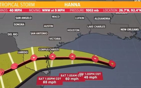
Tropics update: Tropical Storm Hanna shifts south, but Houston area still expecting downpours

We’re looking a little better in Houston as the storm’s forecast track continues to shift south.
HOUSTON — The KHOU weather team and National Hurricane Center are tracking two tropical systems, one of which could bring rain to the Houston area.
Tropical Depression Eight strengthened to become Tropical Storm Hanna late Thursday night in the Gulf of Mexico. It’s headed for the South Texas coast. Meanwhile, Tropical Storm Gonzalo is picking up steam in the Atlantic.
Get the updates on each below.
Tropical Storm Hanna
This is the primary concern for the Texas coast right now, especially the South Texas coast. A Tropical Storm Warning is in effect for much of the South Texas coast. That means tropical storm conditions are expected within the next 36 hours. There’s a Tropical Storm Watch for portions of Galveston County and areas southward.
In Houston, we may only get 1″ to 3″ of rain widespread through the weekend. Closer to the coast, we may get 5″ of rain. This is an improvement from when the forecast track was farther north, and Houston was in the cone of uncertainty.
As of the 4 a.m. Friday update, Hanna’s forecast track has shifted southward, which is good news for Houston. It looks like, at this time, the Corpus Christi area will get the worst of it.
Upper-level wind patterns are sending the system towards Texas. It will bring an increased rain threat to Southeast Texas on Friday and Saturday.
It will not be much of a wind threat for Houston, and we are not expecting it to stall and dump several inches of water.
We’ll see some additional tropical moisture (rain) come our way across the Houston area, which means more robust and heavier downpours. The timing is from Friday to Sunday. We could see rough waves, gusty winds and torrential rain, bringing with it rain between 1 and 4 inches and localized flooding.
Even though we are out of the “cone of uncertainty,” our 7-day forecast shows plenty of rain for the Houston area, much of it due to this tropical system.
Tropical Storm Gonzalo in Atlantic
The second area that we are tracking is Tropical Storm Gonzalo. It is moving westward out of the Atlantic and into the Caribbean sea.
A first glance at the cone looks like it could be bad news for the Gulf of Mexico, but the National Hurricane Center says Gonzalo is “tiny” and could dissipate over the weekend, making it not a major threat to land at this time.
As of the 4 a.m. update on Friday, Gonzalo had winds of 60 mph.