- Sellers and Rantanen are among the NHL trade deadline winners. Hurricanes and Boeser are some losers
- Hurricane forecasters express concern over NOAA job cuts impact
- FEMA deadline for Hurricane Helene recovery aid extended again
- Tornado drills to take place at schools across North Carolina Friday morning
- Hays County emergency alerts cause confusion during Tuesday's wildfires
Tropical Storm Isaias officially forms in Caribbean Sea
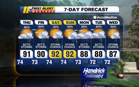
RALEIGH, N.C. (WTVD) — After the activity from early yesterday morning died off, storms took until the afternoon to refire; we did see a few non-severe
storms roll through during the mid to late afternoon. The front that caused those is still off to the northwest of the Triangle, stalled
out across Virginia into Tennessee. It will remain there into the weekend, possibly through Sunday, with a few weak disturbances
tracking eastward along it.
One of those will be heading across the Tennessee Valley today and into the Triangle late tonight, before moving away early
tomorrow. Out ahead of it, we are dry and fairly clear this morning. However, with warm and humid air still in place over the
Triangle, we’ll get building clouds this afternoon along with a shower or thunderstorm into the evening. With the disturbance
pushing our way, some of the storms may bring heavy rainfall, but they should also be scattered. The short range models especially
are showing very little storm coverage through the day, though it does persist well into the night as the upper level energy rolls
through. Temperatures should be around 90 today, very seasonable for late July.
Tomorrow should end up fairly similar to today, with the possibility of another piece of energy rolling by to the north of the Triangle
later tomorrow into tomorrow night.
An upper level trough currently coming out of the Rockies and into the Plains will develop an area of low pressure over the
Mississippi Valley tomorrow. This will track to the northeast along the Ohio River over the weekend. We will stay south of this
feature, but it should serve to pull the weakening boundary farther to the north, especially for Sunday. This should allow for some
warming across the Triangle over the weekend with sun and clouds; there can still be a thunderstorm firing up during each
afternoon. More numerous showers and thunderstorms should pass to our west and north, but also develop to the east and
southeast along the sea breeze boundary that sets up each day.
Starting Sunday, we may also start to see the effects of Tropical Storm Isaias in the eastern part of North Carolina. If the GFS (American computer model) is
correct, the storm may be off the northern coast of South Carolina by late Sunday, while the European model tracks a weaker system into
the far eastern Gulf of Mexico before turning it northward. The GFS takes the storm through very quickly, and it is already gone by
Monday afternoon; we would get very little from the storm. However, the Euro track allows a lot of tropical moisture to get drawn
northward by another trough and front pushing eastward through the Tennessee Valley. This could lead to a couple of days of
rainier weather early next week before drying toward Wednesday. If this were to happen, we could end up with flooding and/or
wind issues in the Triangle. At this time, it is too early to make that call.
Have a great Thursday!
Robert Johnson
Copyright © 2020 WTVD-TV. All Rights Reserved.