- Long-term closures begin on I-10 Katy Freeway to elevate road, prevent flooding
- Texas firefighters helping battle California wildfires
- Western NC teams helping both hurricane and wildfire victims
- New wildfire warnings issued and more power is shut off as winds rise in Southern California
- In wake of wildfires, Spurs' Chris Paul, Victor Wembanyama give JJ Redick's sons their game-worn jerseys
Two tropical storms headed toward Gulf are expected to become hurricanes
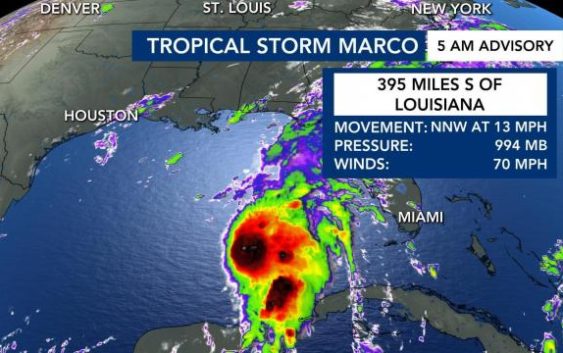
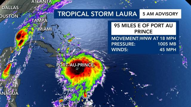
The two tropical storms that are headed toward the Gulf Of Mexico — Tropical Storm Laura and Marco — are expected to become hurricanes. As of Saturday morning, Tropical Storm Marco is nearing the Gulf of Mexico, while Tropical Storm Laura is hovering over the Dominican Republic.
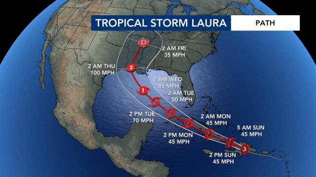
Tropical Storm Laura is expected to gain its Category One Hurricane status by Wednesday and likely gain Category Two strength as it approaches states near the Gulf of Mexico — Texas, Louisiana, Alabama and parts of Florida.
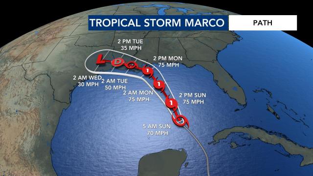
Saturday, Tropical Storm Marco is expected to gain Category One Hurricane status and then weaken as it moves onto the Louisiana shore.
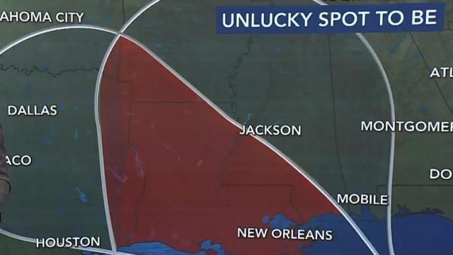
When both these storms make landfall the United States it will be a historic event. Louisiana is in the “Unlucky Corridor” that is expected to take the greatest brunt of both storms.
“This is going to be quite the mess,” said WRAL meteorologist Zach Maloch. “Both systems are going to be impacting the northern Gulf coast states.”
As of 5 a.m., Tropical Storm Marco was nearly 400 miles away from Louisiana and moving at 14 mph. It had winds as strong as 70 mph.
Why the storms gain strength over the Gulf
Water temperatures in the Gulf of Mexico are warm, with temperatures in the mid-80s, which will likely cause each storm to strengthen as it heads towards landfall on the US coast.
“We expect it to gain more strength as it moves into the Gulf of Mexico,” WRAL meteorologist Peta Sheerwood said.
There is a “loop current” in the Gulf of Mexico, Sheerwood said.
Not only is the water warm in the Gulf, but it’s also very deep.
“Warm sea surface temperatures really help these storms fuel and intensify,” Sheerwood said.
As each storm rolls into the warm sea surface temperatures, it is expected to gain strength and be named as a hurricane, Sheerwood said.
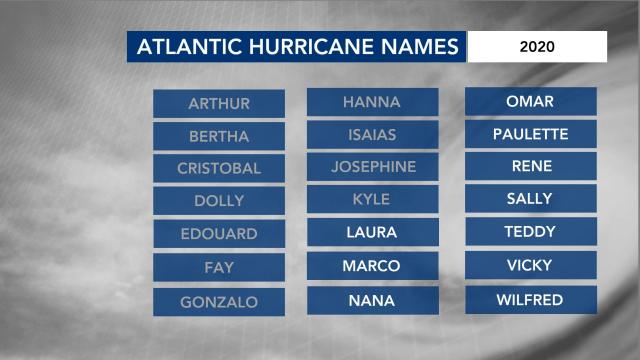
This year’s Atlantic hurricane season has been busy, with record-setting storms. Tropical Storm Marco is the earliest named tropical storm in recorded history, according to WRAL meteorologist Mike Maze. If all the names on the list of 2020 storm names are used before hurricane season ends, meteorologists will use Greek letters to refer to the storms.
The Fujiwara Effect
States along the gulf are going to be severely impacted. When tropical systems get within 800 miles of each other, that is a phenomenon called the Fujiwara Effect.
“In this case … they would be about 400 miles apart and potentially as much as a day apart, but you can still see how close those centers are together,” meteorologist Elizabeth Gardner said on Friday.
If the storms remain at about equal strength, they would rotate around each other, she explained.
“But if, for some reason, Laura strengthens and we get potentially Marcos being stronger, then Marcos could absorb Laura and it could make a stronger storm,” Gardner said.
Tropical Storm Laura could eventually bring North Carolina rain sometime next week, but the timeline is not exactly clear yet.
“There’s certainly the possibility we could have one storm making landfall on Tuesday morning and another making landfall around Wednesday morning along the Gulf Coast in very close proximity,” said Gardner. “That’s something I can never remember happening.”
A third system near Africa will continue to move over the eastern Atlantic this week.
Peak hurricane season runs from mid-August to late October, and hurricane season officially ends on Nov. 30. WRAL meteorologist Elizabeth Gardner said very warm ocean temperatures are contributing to the active hurricane season.
