- Charlotte-based marketing agency announces $20,000 Creative Campaign Grant to help communities after Hurricane Helene
- Artists transform hurricane aftermath into hoop-inspired masterpieces at Charlotte exhibit
- NC's cost for Hurricane Helene damage is nearly $60 billion, state says
- State to develop drone program to better respond to disasters like Helene, Florence
- South Carolina residents face deadline to get storm debris out to the curb after Hurricane Helene
Hurricane Laura: Voluntary evacuation advisory issued for coastal areas of Harris County, Houston by ZIP code
All eyes are on Hurricane Laura, which is strengthening in the Gulf of Mexico. It is expected to become a Category 3 storm by landfall.
HOUSTON — Residents along the Southeast Texas and Louisiana coastlines are keeping a very close eye on Hurricane Laura.
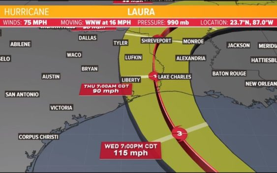
The National Hurricane Center’s latest track for Hurricane Laura has it making landfall, possibly as a Category 3 hurricane, sometime late Wednesday into early Thursday. What we don’t know is exactly where that landfall will occur. A shift of just 20 or 30 miles to the east or west could make all the difference for us in the Galveston-Houston area.
Voluntary evacuation advisories have been issued for other coastal areas, including parts of Harris County and Houston. The advisory is for ZIP codes A and B on this evacuation ZIP code map, which includes routes.
EVACUATIONS: View list of area evacuation orders
Laura becomes a hurricane and enters the Gulf of Mexico
The National Hurricane Center’s 7:15 a.m. update indicated that Laura had reached Category 1 hurricane status with winds at 75 mph. The 10 a.m. update indicated wind speeds had not changed, but it is expected to grow stronger as it moves away from Cuba and north into the warm, open waters of the Gulf of Mexico.
Where will Hurricane Laura go?
The forecast track has remained nearly the same for the last day, putting landfall near the Texas-Louisiana state line. But the cone remains large, and the Houston area is still inside the cone as of the 10 a.m. Tuesday update.
LATEST MODELS: View Laura spaghetti models and forecast cone updates
All communities inside the cone should remain alert and watch for updates over the next 24 hours. The KHOU 11 Weather Team is monitoring for any potential shift to the west, as that would be bad news for us in the Houston and Galveston areas. Landfall will occur sometime late Wednesday night into early Thursday morning.
Hurricane warning and storm surge warnings
In the 10 a.m. update on Tuesday, hurricane warnings were issued from San Luis Pass (on Galveston’s west end) and areas east into Louisiana. There is also a storm surge warning in effect.
Details: A Tropical Storm Warning is in effect for Fort Bend, Grimes, Houston, Inland Brazoria, Inland Harris, Madison, Montgomery, San Jacinto, Trinity, Walker, and Waller – A Tropical Storm Warning and Storm Surge Watch are in effect for Brazoria Islands – A Storm Surge Warning and Hurricane Warning are in effect for Chambers, Coastal Galveston, Coastal Harris, Galveston Island and Bolivar Peninsula, and Southern Liberty – A Hurricane Warning is in effect for Inland Galveston, Northern Liberty, and Polk – A Storm Surge Warning and Tropical Storm Warning are in effect for Coastal Brazoria.
From the NHC: “A Storm Surge Warning means there is a danger of life-threatening inundation, from rising water moving inland from the coastline, during the next 36 hours in the indicated locations. This is a life-threatening situation. Persons located within these areas should take all necessary actions to protect life and property from rising water and the potential for other dangerous conditions. Promptly follow evacuation and other instructions from local officials.”
“A Hurricane Warning means that hurricane conditions are expected somewhere within the warning area. A warning is typically issued 36 hours before the anticipated first occurrence of tropical-storm-force winds, conditions that make outside preparations difficult or dangerous. Preparations to protect life and property should be rushed to completion.”
Laura is not another Harvey
Laura is not another Harvey-like rain event. Yes, there will be rain, but at this point forecasters are more concerned about the storm surge and the wind. And Laura is not expected to “linger” like Harvey did. After landfall, Laura should be clear from the coastline and surrounding areas after just 12 hours or so.
From the National Hurricane Center at 10 a.m. Tuesday, Aug. 25:
1. Laura is forecast to reach the northwestern Gulf Coast at or near major hurricane intensity Wednesday night. Do not focus on the details of the official forecast given the typical uncertainty in NHC’s track and intensity predictions. Storm surge, wind, and rainfall hazards will extend well away from Laura’s center along the Gulf Coast.
2. There is the danger of life-threatening storm surge accompanied by large and dangerous waves from San Luis Pass, Texas, to the Mouth of the Mississippi River, including areas inside the Port Arthur Hurricane Flood Protection system. A Storm Surge Warning is in effect and residents should follow any advice given by local officials. Actions to protect life and property should be rushed to completion today, as water levels will begin to rise Wednesday.
3. Hurricane conditions are expected by Wednesday evening in the area from San Luis Pass. Texas, to west of Morgan City, Louisiana, and a Hurricane Warning is in effect. Tropical storm conditions are expected to begin in the warning area Wednesday afternoon.
4. The threat of widespread flash and urban flooding along with small streams overflowing their banks will be increasing Wednesday night into Thursday from far eastern Texas, across Louisiana, and Arkansas. This will also lead to minor to isolated moderate river flooding. The heavy rainfall threat will spread northeastward into the middle-Mississippi, lower Ohio, and Tennessee Valleys Friday and Saturday.
Make sure you’re prepared for a hurricane
It’s way too early to know the exact intensity and track of Laura, but the one thing you can count on — you’ll be better off if you’re prepared.
Here is a list of important items you should have at home or take with you if you evacuate:
- Water – at least 1 gallon daily per person for 3-7 days; also fill bathtub and other containers; Gator Aid is good to fend off dehydration
- Food – at least enough for 3-7 days; non-perishable packaged or canned food; juices; foods for infants or elderly family members; snack foods; food for special diets
- Non-electric can opener
- Cooking tools, fuel
- Paper plates and cups, plastic utensils
- Bedding: Blankets, Pillows, etc.
- Clothing
- Rain gear
- Sturdy shoes
- First Aid Kit, Medicines, Prescription Drugs
- Toilet paper, paper towels, trash bags
- Toiletries, hand sanitizer, hygiene items, moisture wipes, dry shampoo
- Flashlight, batteries, lantern
- Radio: Battery operated and NOAA weather radio
- Telephones: Fully charged cell phone with extra battery; chargers; traditional (not cordless) telephone set
- Cash (with some small bills) and Credit Cards: Banks and ATMs may not be available for extended periods
- Important documents: Place in a waterproof container or watertight resealable plastic bag: Should include insurance, medical records, bank account numbers, Social Security card, prescriptions, etc.
- Tools: Keep a set with you during the storm
- Gas: Fill up your vehicles several days before landfall is expected; Gas stations could lose power during a storm and supply trucks may not be able to reach the area
- Pet care items: Proper identification, immunization records, medications, ample supply of food and water; a carrier or cage; muzzle and/ or leash
- Bleach without lemon or any other additives
- Fire extinguisher
- Mosquito repellent
- Keys
- Toys, books and games for children
- Duct tape
- Cell Phone charging stations – locations where you can charge mobile devices