- U.S.-based aid groups rush to get supplies into storm-battered Jamaica after Hurricane Melissa
- Travelers stuck in Jamaica due to Hurricane Mellissa forced to pay for unwanted extended stay
- Raleigh police officer awaits word from family in Jamaica after Hurricane Melissa devastation
- North Carolina’s leaders give insight on the effects of Hurricane Melissa
- ‘We want some answers;’ Whiteville residents demand city response to prevent flooding
'Extremely Dangerous' Hurricane Laura makes landfall | Watch live coverage
“Unsurvivable storm surge with large and destructive waves will cause catastrophic damage,” the hurricane center warns.
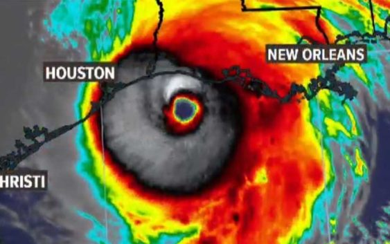
HOUSTON — Residents in far Southeast Texas and western Louisiana braced for the worst of the impacts from Hurricane Laura, which was a major hurricane at landfall late Wednesday night.
The hurricane brought with it a deadly storm surge. Rescuers will not be able to reach those who choose to not evacuate from areas like Port Arthur, state and county leaders warn.
LIVE VIDEO NOW: We are streaming live coverage from our sister station KBMT in Beaumont in the video player on this page
In its 11 p.m. update Wednesday, the National Hurricane Center said Laura still had max sustained winds at 150 mph with gusts up to 175 mph. If max sustained winds get to 157 mph, it’ll be a Category 5 hurricane.
“Catastrophic storm surge, extreme winds and flash flooding is expected along the northwest Gulf Coast tonight. Only a few hours remain to protect life and property,” the NHC warned residents of the eastern Texas and western Louisiana coasts early this morning. “Unsurvivable storm surge with large and destructive waves will cause catastrophic damage from Sea Rim State Park, Texas, to Intracoastal City, Louisiana, including Calcasieu and Sabine Lakes. This surge could penetrate up to 30 miles inland from the immediate coastline.”
WHY IT WON’T TURN TOWARD HOUSTON: Experts say it’s unlikely
FORECAST TRACK: View Laura spaghetti models and forecast cone updates
Where is Hurricane Laura going?
The National Hurricane Center’s latest track for Hurricane Laura has it making landfall, likely as a Category 4 hurricane. The models are coming to an agreement about location. It looks to be right along the Louisiana-Texas border.
In Houston, we can breath a sigh of relief that we will not get the worst of Laura. But we should also stay informed and stay prepared. We should also send our support and thoughts to our neighbors to the east. This includes the Port Arthur, Beaumont and Lake Charles areas.
Where is Hurricane Laura now?
As of the 11 p.m. NHC update, Hurricane Laura was 60 miles south of Lake Charles, moving to the north-northwest at 15mph.
The cone of uncertainty is getting narrower along the coast the closer the hurricane gets, which means the Houston area is thankfully no longer in the cone.
All communities inside the cone should remain alert and watch for updates through landfall. The KHOU 11 Weather Team is monitoring for any potential shift to the west, as that would mean a greater storm surge for our coastal communities.
What is the danger from Hurricane Laura?
Storm surge is among the worst of the dangers followed by the wind for those in the Beaumont and Port Arthur areas. Yes, there will be rain, but this will not be a Harvey-like flooding event. The hurricane will not linger and should be cleared of the landfall area after about 12 hours.
Galveston can still expect about a five foot storm surge (well within the limits of the seawall) while closer to Beaumont and into Lake Charles there will be about a 10 foot storm surge:
The storm surge could penetrate up to 30 miles inland from the southwest Louisiana coastline and far southeastern Texas. Damaging wind and gusts are expected to spread well inland into parts of eastern Texas and western Louisiana early Thursday.
There’s also the possibility of widespread flash flooding along small streams and roadways in far east Texas, Louisiana and Arkansas.
Make sure you’re prepared for a hurricane
It’s way too early to know the exact intensity and track of Laura, but the one thing you can count on — you’ll be better off if you’re prepared.
Here is a list of important items you should have at home or take with you if you evacuate:
- Water – at least 1 gallon daily per person for 3-7 days; also fill bathtub and other containers; Gator Aid is good to fend off dehydration
- Food – at least enough for 3-7 days; non-perishable packaged or canned food; juices; foods for infants or elderly family members; snack foods; food for special diets
- Non-electric can opener
- Cooking tools, fuel
- Paper plates and cups, plastic utensils
- Bedding: Blankets, Pillows, etc.
- Clothing
- Rain gear
- Sturdy shoes
- First Aid Kit, Medicines, Prescription Drugs
- Toilet paper, paper towels, trash bags
- Toiletries, hand sanitizer, hygiene items, moisture wipes, dry shampoo
- Flashlight, batteries, lantern
- Radio: Battery operated and NOAA weather radio
- Telephones: Fully charged cell phone with extra battery; chargers; traditional (not cordless) telephone set
- Cash (with some small bills) and Credit Cards: Banks and ATMs may not be available for extended periods
- Important documents: Place in a waterproof container or watertight resealable plastic bag: Should include insurance, medical records, bank account numbers, Social Security card, prescriptions, etc.
- Tools: Keep a set with you during the storm
- Gas: Fill up your vehicles several days before landfall is expected; Gas stations could lose power during a storm and supply trucks may not be able to reach the area
- Pet care items: Proper identification, immunization records, medications, ample supply of food and water; a carrier or cage; muzzle and/ or leash
- Bleach without lemon or any other additives
- Fire extinguisher
- Mosquito repellent
- Keys
- Toys, books and games for children
- Duct tape
- Cell Phone charging stations – locations where you can charge mobile devices