- Jarvis stars as the Hurricanes beat the Kraken 4-1 for their 3rd straight win
- Houston Cougars take on A&M Aggies in charity exhibition game supporting Hurricane Beryl relief
- Hurricane Helene donations delivered to Avery County for Share the Warmth campaign
- Old Crow Medicine Show founder talks music, hurricane relief and this weekend's big benefit show
- IV fluid shortage caused by hurricane to last for months
Here is where Hurricane Laura is going now after landfall
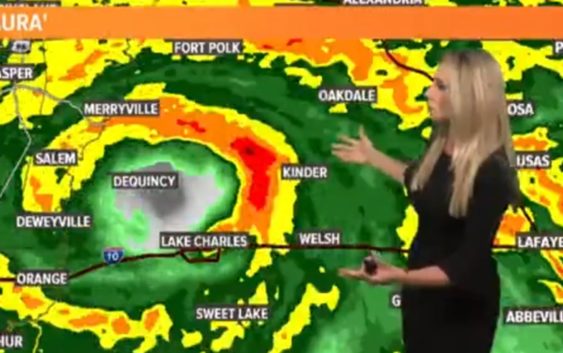
HOUSTON — Residents in western Louisiana received the worst impacts from Hurricane Laura, which was a major Category 4 hurricane at landfall late Wednesday into early Thursday morning.
The hurricane brought with it a deadly storm surge and damaging winds, but at this time it appears Texas was spared the worst of the weather.
LIVE VIDEO NOW: The video player on this page is tracking Hurricane Laura (no audio)
As of 10 a.m. Thursday, the hurricane was downgraded to a Category 1 storm as it moved north and farther inland. Max sustained winds were 75 mph, which means in the next update it will likely be downgraded again to a tropical storm.
Early this morning there were nearly 100,000 without power in the Beaumont area. In Houston, we didn’t even get strong enough wind gusts to knock out power, and our rain chances are decreasing as the storm kept to the east.
Where will Laura go after landfall?
You can watch Meteorologist Chita Craft’s Thursday morning weather update here, and view our interactive tropical tracker map below:
There is no danger from this tropical system that it will loop back around to the coast and bring flooding rains, unlike in the past. Hurricane Laura is moving north fast, which means flooding (from the rain) will not be a widespread issue – even in Louisiana.
In the tropical tracker below you can see Laura will continue to move north in Louisiana, just east of East Texas. Texas is on the “dry side” of the storm, but those near the border will still get gusty winds and rain, including in Lufkin and Nacagdoches.
The hurricane’s center will head north between Shreveport and Monroe before heading into Arkansas and continuing to lose intensity.
Track Hurricane Laura
Hurricane season is not over: stay prepared
Here is a list of important items you should have at home or take with you if you evacuate before a hurricane:
- Water – at least 1 gallon daily per person for 3-7 days; also fill bathtub and other containers; Gator Aid is good to fend off dehydration
- Food – at least enough for 3-7 days; non-perishable packaged or canned food; juices; foods for infants or elderly family members; snack foods; food for special diets
- Non-electric can opener
- Cooking tools, fuel
- Paper plates and cups, plastic utensils
- Bedding: Blankets, Pillows, etc.
- Clothing
- Rain gear
- Sturdy shoes
- First Aid Kit, Medicines, Prescription Drugs
- Toilet paper, paper towels, trash bags
- Toiletries, hand sanitizer, hygiene items, moisture wipes, dry shampoo
- Flashlight, batteries, lantern
- Radio: Battery operated and NOAA weather radio
- Telephones: Fully charged cell phone with extra battery; chargers; traditional (not cordless) telephone set
- Cash (with some small bills) and Credit Cards: Banks and ATMs may not be available for extended periods
- Important documents: Place in a waterproof container or watertight resealable plastic bag: Should include insurance, medical records, bank account numbers, Social Security card, prescriptions, etc.
- Tools: Keep a set with you during the storm
- Gas: Fill up your vehicles several days before landfall is expected; Gas stations could lose power during a storm and supply trucks may not be able to reach the area
- Pet care items: Proper identification, immunization records, medications, ample supply of food and water; a carrier or cage; muzzle and/ or leash
- Bleach without lemon or any other additives
- Fire extinguisher
- Mosquito repellent
- Keys
- Toys, books and games for children
- Duct tape
- Cell Phone charging stations – locations where you can charge mobile devices