- Hays County emergency alerts cause confusion during Tuesday's wildfires
- Tuesday's wildfires scorched more than 500 acres in south Bexar County
- How big were this week's wildfires in Bexar County?
- Crews contain wildfire in southeast Williamson County
- Wildfire contained to 300 acres in northwest Matagorda County
Former Hurricane Laura now strong tropical storm, with winds of 70 mph
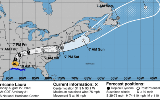
Damaging winds and flooding rain are spreading inland over central and northern Louisiana, according to the noon advisory from the National Hurricane Center.
By noon Thursday, Laura weakened into a strong tropical storm, less than 24 hours after it made landfall as a powerful Category 4 hurricane with 150 mph winds.
Hurricane Laura made landfall near Cameron, Louisiana, at 1 a.m. Thursday.
As of noon, the center of Tropical Storm Laura was located 50 miles east-southeast of Shreveport, Louisiana.
Laura is moving toward the north near 15 mph.
More: See photos, videos of Hurricane Laura damage in Texas
More: As Hurricane Laura approaches landfall, here’s what to do if storm causes flooding
On the forecast track, Laura will move north across northern Louisiana this afternoon. The center of Laura is forecast to move over Arkansas tonight, the mid-Mississippi Valley on Friday, and the mid-Atlantic states on Saturday.
Maximum sustained winds continue to drop, and were at 70 mph, with higher gusts, at noon.
Laura is expected to become a tropical depression tonight.
More: Watch live webcams of Texas beaches
Where is Hurricane Laura now?
- Location: 50 miles southeast of Shreveport,, Louisiana
- Movement: North at 15 mph
- Maximum sustained winds: 70 mph
- Next update: 1 p.m.
Information gathered from the National Hurricane Center.
Hurricane Laura watches and warnings
A storm surge warning is in effect for:
- Sabine Pass Texas to Port Fourchon Louisiana
A tropical storm warning is in effect for:
- High Island Texas to the Mouth of the Mississippi River
Read or Share this story: https://www.caller.com/story/news/2020/08/27/hurricane-laura-landfall-track-path-nhc-updates-texas-louisiana/3439752001/