- Report: Coastal flooding could threaten 1.4 million homes by midcentury
- Caught on camera | Tornado touches down in Missouri
- Carolina Hurricanes playoff tickets go on sale next week
- Storms kill 6 in the South and Midwest as forecasters warn of catastrophic rains, floods this week
- Weather Impact Alert: Cold front could trigger severe weather in Houston area this weekend | See timeline
Flooding Chances Ramp Up Today

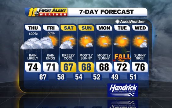
As Sally continues to track east-northeast across South Carolina and southeastern North Carolina tonight into early tomorrow, we’ll see a wide swath of heavy, overrunning rainfall developing. This is when we will pick up most of our rain, and widespread amounts of 2-5 inches are likely. There could end up being a significant gradient across the area, with far south/east areas getting closer to 2 inches, but areas to the north and west of Durham will pick up a solid 4 inches.
Because of the flooding potential, the NWS has the entire area under a flash flood watch.
The good news is that the models have come into decent alignment on the speed of Sally, and they carry the center of the storm to right along the coast by daybreak tomorrow. This will mean a quick end to the heavy rain Friday, and though the northeast flow that lingers behind the storm tomorrow can still funnel in some lighter rain or perhaps just a bit of drizzle, we begin to dry out. Clouds will hold on though, and it will be a breezy and cool day on Saturday. Dew points begin to fall as well as we feel the influence of the next high pressure area pushing through the Great Lakes; this is what drives a cold front our way and steers Sally out to sea.
As that high pressure area settles over the Northeast for the weekend and into early next week, the flow will remain northeasterly. While there will be drier air pushing into the region, it will be battling with the low-level moisture being drawn in on the northeasterly flow.
Additionally on Saturday, a southwesterly flow aloft up and over the northeasterly flow can have a lot of mid- and high clouds across the sky; all of this will make it tough for us to clear completely Saturday. However, it will be mostly sunny Sunday as the drier air continues to push deeper into the area.
Have a great Thursday and stay dry!
Big Weather
Copyright © 2020 WTVD-TV. All Rights Reserved.