- Cast of Scandal reunites to show support for western North Carolina after Hurricane Helene
- Tropical Storm Sara threatens to bring flash floods and mudslides to Central America
- Hurricane-stricken Tampa Bay Rays to play 2025 season at Yankees' spring training field in Tampa
- Utah scores 3 goals in 2 1/2 minutes in 3rd, Vejmelka has 49 saves in 4-1 win over Hurricanes
- Driver dies after crashing off hurricane-damaged highway in North Carolina
Triangle under Level 2 storm threat; flooded roads and damaging winds expected
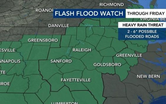
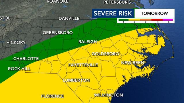
Much of the state is under a flash flood watch and a Level 2 risk for severe storms on Thursday and into Friday evening.
Remnants from Sally are bringing us excessive rainfall and flooding. Rain will be possible all day on Thursday and Friday. WRAL’s Severe Weather team says to expect the heaviest rain on Thursday afternoon and evening.
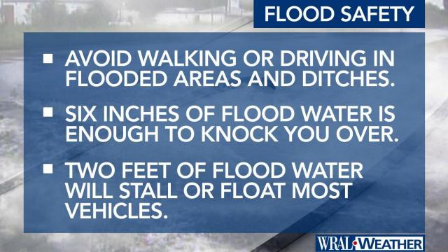
If you are driving on Thursday evening, be aware of flooded roads, which can be deadly. Do not try to drive through standing water or washed out roads.
Earlier this month, two young children riding in their mother’s car in Smithfield died when the car was swept away in floodwaters. Eight inches of rain was reported in the area. Their bodies were found days later in a shallow creek near the Neuse River.
Sally has been downgraded to a tropical depression. The storm made landfall in Alabama at around 6 a.m. on Wednesday as a Category 2 storm. The remains of Sally will cause a remnant low south of North Carolina.
Heavy rains and saturated ground trees could come down and power outages are possible on Thursday and Friday. Wind gusts are expected to pick up to 20 to 30 mph, which could also knock over trees.
Flooding risk
WRAL meteorologist Elizabeth Gardner said the number one risk for Thursday is flooding.
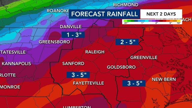
The Triangle is expecting 2 to 5 inches in the next two days from these storms.
“There are going to be places that don’t see flooding and there are going to be places that do,” said Gardner.
Minor river flooding is also forecast for several area rivers.
City of Raleigh officials said that flooding is possible on the Capital Area Greenway System. Officials said to not attempt to cross flood waters covering any part of the Greenway.
Slowdown if you come across asphalt, concrete or wooden bridges that are flooded.
The flash flood watch expires at 11 a.m. on Friday.
Level 2 risk for severe weather
The highest risk for severe weather is under the center of circulation.
Storms rolling in on Thursday could cause damaging wind gusts from faster moving bands of rain and tropical downbursts. There is also the chance of a weak tornado or two. The chance for tornados is low, according to WRAL meteorologist Zach Maloch.
Thunderstorms should move out of our area by Friday night.
NC prepares for storms
Wake County’s free coronavirus testing site at the Sunnybrook parking deck will close at noon on Thursday ahead of storms.
Anyone who has a scheduled appointment can come back at any time on Friday to get tested for the coronavirus.
Governor Roy Cooper will talk about the soaking rain and flooding risks North Carolina is facing in a press conference on Thursday at 3 p.m.
The state already had national guardsmen and swift water rescue teams on standby.
