- Sellers and Rantanen are among the NHL trade deadline winners. Hurricanes and Boeser are some losers
- Hurricane forecasters express concern over NOAA job cuts impact
- FEMA deadline for Hurricane Helene recovery aid extended again
- Tornado drills to take place at schools across North Carolina Friday morning
- Hays County emergency alerts cause confusion during Tuesday's wildfires
South Texas And Mexico Watch New Tropical Danger Emerging In Gulf

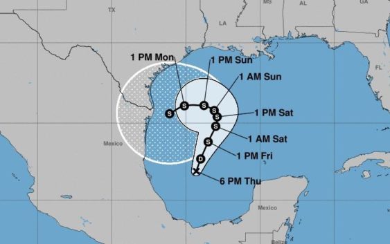
Tropical Depression Twenty Two was born off Mexico’s Gulf coast on Thursday evening, and National Hurricane Center forecasters warned the storm could soon strengthen into a tropical storm.
The depression is moving toward the northeast near 5 mph, and it is expected to generally meander over the western Gulf of Mexico into the weekend,” the NHC advisory explained. “Maximum sustained winds are near 35 mph with higher gusts. Some strengthening is forecast during the next couple of days, and the depression could become a tropical storm on Friday.”
If the depression grew into a tropical storm, the NHC would name it Wilfred. That is the last name on the NHC’s 2020 list of “Tropical Cyclone Names.” Any other storms that emerge in the Atlantic, Gulf and Caribbean will receive names from the Greek alphabet.
It was not yet clear how the system could impact the Texas coast, aside from the expected higher surf and storm surge.
The depression in the Gulf of Mexico emerged near the end of a historically busy week in the Atlantic, Caribbean and Gulf regions.
Sally made a dangerously slow landfall near Gulf Shores, Ala., on Wednesday morning as a Category 2 hurricane, flooded several states throughout the southeastern U.S. and killed at least one person in Alabama.
By Thursday afternoon, the NHC had issued its final advisory on Sally — essentially closing the books on the drama — and officially classified it as a post-tropical depression. Sally’s remnants were expected to continue flooding Georgia and the Carolinas.
NPR reported that Sally will remain notable because of its intense flooding — measured in some places in feet rather than inches — and because it surprised experts and residents both by growing quickly in the final moments before landfall and by its sudden shift to the east, from Louisiana to Alabama.
The NHC also monitored Teddy, which grew to a Category 4 hurricane and threatened Bermuda, and Vicky, a tropical depression that dissipated over the central Atlantic by Thursday evening. Also, a weak system southwest of the Cabo Verde Islands off West Africa could grow into a tropical depression this weekend.
[12pm AST Sep 17] We’re monitoring the #GOESEast mesoscale imagery of Major Hurricane #Teddy as it continues to intensify.
These high resolution images are updated every minute, allowing meteorologists to assess quick changes in storm structure. pic.twitter.com/Eth3xWOibx
— NHC_TAFB (@NHC_TAFB) September 17, 2020
TPR was founded by and is supported by our community. If you value our commitment to the highest standards of responsible journalism and are able to do so, please consider making your gift of support today.