- Hays County emergency alerts cause confusion during Tuesday's wildfires
- Tuesday's wildfires scorched more than 500 acres in south Bexar County
- How big were this week's wildfires in Bexar County?
- Crews contain wildfire in southeast Williamson County
- Wildfire contained to 300 acres in northwest Matagorda County
Tornado warning, severe storms impact areas south and east of the Triangle
Raleigh, N.C. — As part of the rain, storms and flash floods forecast for parts of NC this evening as the remnants of Beta pass over, a Tornado Warning was issued for Robeson County until 6:45 p.m. and a Severe Thunderstorm Warning is in effect for Cumberland, Harnett, Hoke, and Moore counties until 7:15 p.m.
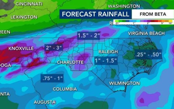
Remnants from Beta will bring pockets of rain to us all evening on Friday.
As of Friday afternoon, the Triangle has seen about half an inch to an inch of rain. Flash flooding is no longer a major threat for the WRAL viewing area on Friday, according to meteorologist Aimee Wilmoth. The Triangle is still under a low risk for flash flooding for Friday, but that risk has decreased.
Counties in the southwestern parts of North Carolina could experience flash flooding from Friday’s rain.
In our area, there is a wide temperature spread this afternoon. For example, on Friday afternoon it was 59 degrees in Roxboro compared to 71 degrees in Fayetteville.
A warm front is trying to edge into our southern counties. The front could cause enough instability for a few storms in southern parts of the state.
Scattered showers and storms will stay with us on and off throughout the entire day on Friday.
The only active warnings in the state are in Craven and Lenior counties. If you are in that area, you should watch out for possible flooding.
While some thunderstorms will be possible with the rain, severe weather is not expected. There will not be widespread flooding, but if heavy rain falls in one area for a length of time, ponding on roads could become dangerous.
Our weekend outlook shows an 80% chance of rain and storms on Friday, with a 30% chance of rain on Saturday.
By Saturday, the persistent rain will taper off, and Gardner said it will be a nice weekend overall. A few showers could linger into Saturday, but widespread rain is not expected this weekend.

Much of the weekend should be dry – especially Sunday.
Beta has dissipated and is no longer a tropical depression, but before it weakened the storm dropped close to 15 inches of rain in Texas. In contrast, the Triangle will see less than 1.5 inches of rain from Beta’s remnants.
Although elevated dew points could make the air feel steamy and summer-like again, the Climate Prediction Center’s temperature outlook for Sep. 29 through Oct. 5 shows below-normal temperatures for North Carolina.
Highs will be in the lower 80s for the weekend and early next week, but fall-like weather returns Wednesday.
