- Hays County emergency alerts cause confusion during Tuesday's wildfires
- Tuesday's wildfires scorched more than 500 acres in south Bexar County
- How big were this week's wildfires in Bexar County?
- Crews contain wildfire in southeast Williamson County
- Wildfire contained to 300 acres in northwest Matagorda County
Severe weather, flash flooding risks this week
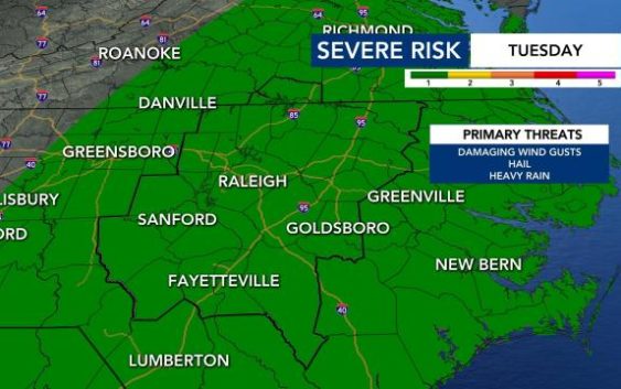
Raleigh, N.C. — A cold-front moving into the region will bring heavy rain and even the potential for severe storms this week. Excessive rainfall could onset flooding across the viewing area Tuesday.
Monday is going to be warmer than usual, with a high of 82 degrees. Then on Wednesday temperatures are back down again to 72 degrees, which is below the regular temperature for this time of year.
Monday morning will start out fairly dry, with possibly some drizzle and patchy fog.
“As we get into the afternoon and evening, we could see a couple isolated showers,” said WRAL meteorologist Aimee Wilmoth.
Monday will have a 30% chance of rain, but will jump to to 80% chance of rain on Tuesday and a 60% chance on Wednesday.
“Bascially at any point in time on Tuesday, we’ll have the potential for showers and thunderstorms,” explained Wilmoth.
On Tuesday, most of the state is under medium risk for flash flooding due to heavy rainfall. Over the next five days we could expect 1.5 to 2 inches of rainfall.

Wednesday will also have enhanced rain chances.
“We’ll have periods on rain Tuesday and Wednesday,” said Wilmoth. “Some of that rain will be heavy at times and will have the potential for flooding and maybe severe weather.”
WRAL meteorologist Peta Sheerwood said that drier days are ahead, we’ll just have to wait until Thursday until we feel that dry air move in.

Although elevated dew points could make the air feel steamy and summer-like again, the Climate Prediction Center’s temperature outlook for Sep. 29 through Oct. 5 shows overall below-normal temperatures for North Carolina.
