- National memorial to honor NC firefighter who died on duty during Hurricane Helene
- Gov. Josh Stein extends State of Emergency for western NC wildfires
- Governor Stein extends state of emergency for NC wildfire threat
- Governor Stein extends emergency in 34 NC counties amid wildfire threat
- Texans can buy emergency preparation supplies tax-free April 26-28 ahead of severe weather season
Level 1 Severe Weather Risk for Parts of NC
RALEIGH, N.C. (WTVD) — A warm front associated with post-tropical cyclone Delta is providing the possibility of severe weather for the Sandhills and southern half of the Coastal Plain tonight. This warm front has allowed for thunderstorms to grow and has produced weak rotation within these storms and have prompted tornado warnings. The main threat for south-central NC is a damaging wind gust or even an isolated tornado. The storm threat will begin to diminish after 8pm.
Over the next several hours, the Sandhills & southern half of the Coastal Plain should remain weather aware. We’ve already seen tornado warnings appear just west and south of the @ABC11_WTVD viewing area (counties outlined in black).
Main threat=damaging winds, isolated tornado. pic.twitter.com/gkxtZki6h6— Robert Johnson (@RobJohnsonABC11) October 11, 2020
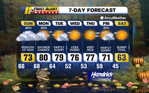
Otherwise, tonight will feature scattered showers and storms and some of them will be quite strong.
A few remnant showers will be around for tomorrow, mainly in the morning, but there won’t be any severe weather tomorrow. Monday will be warm and humid with limited sunshine and highs in the upper 70s/low 80s.
A cold front moves through the Carolinas on Tuesday and will allow for drier air to filter into our region. High pressure will build in behind the front and provide a mostly sunny sky. This will remain until Friday when another cold front arrives and brings the chance for a few PM showers.
Be Well & Stay Safe!
Robert Johnson
Copyright © 2020 WTVD-TV. All Rights Reserved.