- Weather Impact Alert: Heavy rain could lead to flooding across Carolinas
- North Carolina legislators fleshing out details on $500M in additional Hurricane Helene relief
- Dangerous travel conditions: Ice, snow and flooding possible
- How photos lost in disasters like Hurricane Helene find their way home, with a little help from people who care
- Dangerous travel conditions, ice/snow and flooding possible in the mountains Tuesday and Wednesday
Some schools close, move to online learning during severe weather
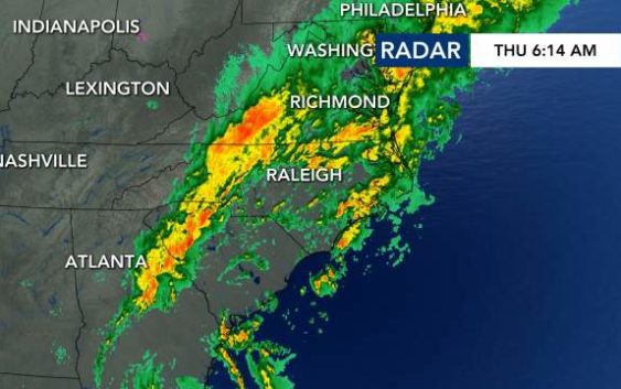
Raleigh, N.C. — Heavy rain will continue to fall across central North Carolina Thursday, creating a risk for flash flooding.
Overnight, flooding east of the Triangle closed Interstate 95 in Wilson County and prompted water rescues in surrounding neighborhoods.
By 6 a.m., Rocky Mount reported close to 6 inches of rain, and Wilson County Schools and Edgecombe County Public Schools canceled all in-person and remote learning for Thursday. Nash County Public Schools and Johnston County Public Schools announced all students will learn remotely on Thursday because of the anticipated heavy rain and possible flash flooding.
In the Triangle, the rain led to several traffic crashes overnight. With heavier rain continuing all day Thursday, everyone is at risk for flash flooding, according to WRAL meteorologist Elizabeth Gardner.
Between 2 to 4 more inches of rain are possible in the Triangle over the next 24 hours, bringing the threat for flooding conditions, road closures and crashes to much of North Carolina.
Gardner said Thursday’s rain will be heaviest in the morning and throughout the day, tapering off around 5 p.m. More rain is expected to fall east of the Triangle, but anyone could see flash flooding as downpours drop heavy rain across the state.
More than half of North Carolina’s 100 counties – including Wake, Durham and Cumberland — remain under a flash flood watch through Thursday at 7 p.m. The entire viewing area is under a Level 1 risk for severe weather, so gusty winds and isolated tornadoes can’t be ruled out.
By the weekend, temperatures will be more seasonal, with highs in the mid-60s and overnight lows in the mid-40s. The rain clears by Saturday, although some clouds are possible on Sunday.

Wednesday rain and flooding
Heavy rain on Wednesday led to flash flooding in Rocky Mount and Wilson. At one point overnight, the Doppler radar showed up to 7 inches of rain around the Rocky Mount area.
While some places had over an inch of rain fall on Wednesday, WRAL meteorologist Kat Campbell said Wednesday was the wettest day in the last 20 years at the Rocky Mount-Wilson Airport, with over 5 inches of rain in six hours

The southbound lanes of I-95 near Wilson (Exit 119) were closed because of flooding until 2 a.m.
“We probably had five or six inches of water surrounding my house,” said Wilson County resident Chip Morris. “We’ve been here 12 years and we’ve never had anything close to that.”
WRAL’s Rosalia Fodera said a tractor-trailer also got stuck in the median of I-95 in Wilson. North Carolina State Highway Patrol was working on Wednesday night to get cars around the stuck tractor-trailer.
Thursday’s weather also caused a five-car accident in Nash County that blocked parts of U.S. Highway 64.
In Fuquay-Varina, the driver of a large truck carrying gravel lost control and flipped on its side on Wednesday afternoon. The driver of the truck was taken to a local hospital for treatment. Law enforcement said the driver is expected to be okay.