- Seven months after Hurricane Helene, Chimney Rock rebuilds with resilience
- Wildfire in New Jersey Pine Barrens expected to grow before it’s contained, officials say
- Storm damage forces recovery efforts in Lancaster, Chester counties
- Evacuation orders lifted as fast-moving New Jersey wildfire burns
- Heartbreak for NC resident as wildfire reduces lifetime home to ashes
The latest: Police search for missing child in Rolesville flooding, NC officials say stay at home
Heavy rain and flooding conditions worsened throughout the day on Thursday, according to WRAL meteorologist Elizabeth Gardner, but much of the rain should be out of the area by this evening.
In a press conference at 2 p.m., North Carolina officials urged people do stay off the roads for the remainder of the day.
What to know:
- The entire viewing area, including the Triangle, is under a flash flood watch until 7 p.m. View all alerts.
- A flash flood warning for most of central North Carolina was extended to 4:15 p.m.
- Sudden downpours and dangerous flash flooding are possible throughout the afternoon. Conditions should improve around 5 p.m.
- Flooding is most severe east of Raleigh, where more than 7 inches have fallen in the Rocky Mount area, and up to 12 inches are possible.
Helpful links: View all active weather alerts | Track the rain with the DualDoppler5000 | Get a live look at Triangle weather conditions
The latest:
2:15 p.m.: In a press conference, state officials said North Carolina drivers should stay off the roads all day Thursday unless they absolutely must go somewhere. Emergency rescue workers have had to save people trapped by flood waters, officials said.
Rolesville police say they’re searching for a child reported missing near a creek. The child was last seen near 5700 block of Lord Granville Way.
WRAL’s Bryan Mims reports that Selma is home to the most 9-1-1 calls in Johnston County. Selma Police Chief Billy Thomas called WRAL’s Mark Boyle to ask residents to stay off the roads.
2:00 p.m.: WRAL’s Mike Maze says conditions are improving in the western part of the state. Eastern counties, however, still have up to three hours of rain remaining in the forecast.
The North Carolina Department of Transportation reported that I-95 is closed in both directions near Wilson, around Exit 121. The department expects the highway to reopen by 5:00 a.m.
1:30 p.m.: The Tar River in Rocky Mount is rising quickly, where numerous water rescues have been reported. Rocky Mount has seen almost 9 inches of rain in the past 24 hours, more than any other community in the viewing area. U.S. 301 was especially flooded at Tarboro Road, where the highway looked more like a river.
1:00 p.m.: WRAL Bryan Mims is monitoring conditions in Wilson, where multiple roads are still blocked due to standing water. The county said first responders have rescued at least 20 families that tried to drive through floodwaters since Wednesday.
In Raleigh, fewer roads are flooded, but streets are still wet and dangerous. A crash on I-40 West has slowed traffic at Exit 287 for Aviation Parkway. Heavy delays were reported in the area.
Three cars were involved in a crash on I-40 West near U.S. 1 in Cary. No one appeared to be injured.
12:45 p.m.: WRAL Aimee Wilmoth said the back edge of the rain is nearing the Triad, and the line of heaviest rain will be in our eastern counties around 2 p.m. The bulk of the rain should be out of central North Carolina by 3 or 4 p.m.
The Storm Prediction Center canceled a severe risk for most of the viewing area, so gusty winds, tornadoes and hail are no longer a major concern.
12:30 p.m.: At St. David’s, a private school on White Oak Road in Raleigh, Coach Dan Casey tweeted a photo of a flooded football field. The school is scheduled to host a state playoff game Friday night.
More than 5,000 customers are without power in North Carolina, according to Duke Energy. Rather than being clustered in one area, outages are scattered throughout the state.
12:15 p.m.: Cumberland and Wake counties are dismissing schools two hours early as flooding persists across the viewing area. Harnett County announced it will close schools at 1 p.m.
12:00 p.m.: Jamie Kritzer with the N.C. Department of Transportation said 160 road closures have been reported statewide, and they’ve been building throughout the day. He urged drivers to respect barricades and signs blocking flooded roads and reminded them to never drive through standing water. It’s a good idea to travel 10 mph slower than the speed limit when roads are wet, he said, and keep an extra distance between cars.
11:45 a.m.: In western North Carolina, it was a scary moment for a FOX 46 reporter in Alexander County when she was standing on the Hiddenite Bridge right before it collapsed. The frightening moment was captured live on air.
11:30 a.m.: At Crabtree Creek near Wake Forest Road in Raleigh, which usually floods during heavy rain events, the creek is already rising and a caution sign is alerting drivers for possible road flooding. A Honda dealership was moving some of its vehicles to higher ground in preparation for possible flooding.

Wake County deputies are also responding to some reports of power outages and fallen trees. Trees are down at Bells Lake Road and Johnson Pond Road near Fuquay-Varina, and a stoplight is out at N.C. Highway 42 and Rock Service Station Road. Standing water was also reported at at 730 Ferrell Road in Knightdale.
11:00 a.m.: Nia Harden is in the Storm Tracker checking out road conditions across the Triangle, where most roads are seeing some ponding. WRAL Elizabeth Gardner said our southern counties have now been added to the flash flood warning as a band of heavy rain approaches those areas.
10:45 a.m.: Even in Fayetteville, which escaped much of the flooding, a neighborhood is flooded on Bombay Drive where a creek overflowed. The City of Fayetteville has placed road barricades on Bombay Drive, Ray Avenue at Cross Creek, Orange Street, Devonshire Drive, NC-53 and Englewood Drive, near the Ann Street Bridge and on L A Dunham Road due to rising waters. Cumberland County is now under a flash flood warning until 4:30 p.m.

10:30 a.m.: When will the rain start to taper off today? WRAL Zach Maloch said our western counties, including Orange, Durham and Person, should see the rain coming to an end by 4 p.m. In Raleigh and Cary, it will taper off closer to 5 p.m.
The bulk of the rain should be out of the area completely overnight, with just a stray shower possible early Friday. A total of 1-3 more inches of rain could fall over the next 3-4 hours, Maloch said.
Meteorologists are closely watching the Neuse River, which could be at moderate flood stage in Goldsboro by Friday. The Neuse could be at moderate flood stage in Smithfield and Clayton by Thursday night.
10:15 a.m.: On Fountain Drive in southeast Raleigh, Walnut Creek overflowed its banks, flooding the bottoms of several cars parked in the community. The road has been blocked off to traffic.
A homeowner who lives at the bottom of a hill in the community told WRAL Amanda Lamb water entered her home but it is starting to recede. She said this happens often in heavy rain events and she has gotten used to it.

New crashes have been reported on major Raleigh routes, including on I-40 East at Rock Quarry Road and on I-440 E near Hillsborough Street and Wade Avenue. Flash flooding was also reported on Lake Boone Trail near I-440.
While school days have not changed in the Triangle, Wake County Public Schools announced food distribution to students learning remotely has been canceled Thursday due to inclement weather.
10 a.m.: Conditions are also poor in western North Carolina, where water rescues are underway. The Conover Fire Department tweeted a group of 15 to 20 campers were trapped at the Hiddenite Family Campground.
According to WCNC Charlotte, Duke Energy estimated nearly 2,500 people were without power in Catawba County due to the storms. The station reports 143 people were evacuated from Corvian Community Elementary School in Charlotte because of floodwaters.
In Charlotte, I-85 looked more like a river at one point Thursday morning. A record was broken near uptown Charlotte, where Little Sugar Creek recorded a record crest of 15.2 feet, the highest it’s been since 1997.
Storms and heavy rain will continue to move eastward, and Gardner said “the situation will only get worse” Thursday. Anywhere from 1-2 inches of rain could fall per hour.
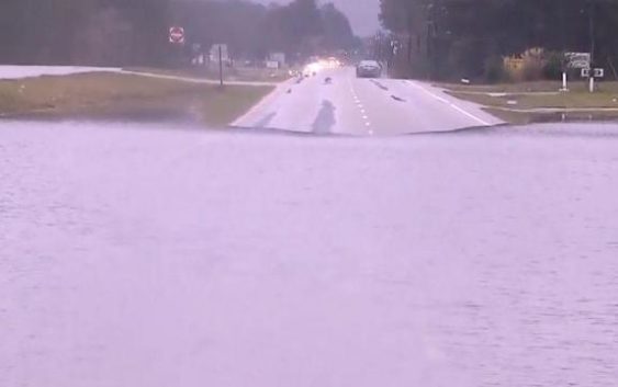
Conditions continue to be worst east of Raleigh, where U.S. Highway 301 in Rocky Mount and Old Route 22 in Kenly are flooded.
9:45 a.m.: More than 7 inches of rain have already fallen in the Rocky Mount, and at least 3 inches fell in the Triangle. On Thursday, isolated heavy downpours will continue to drop another 2 to 5 inches across the state.
9 a.m.: A flash flood warning is in effect for the Triangle and Sandhills, including Wake County, until 2:15 p.m. Flash flooding can occur unexpectedly from heavy downpours, flooding roads and making for dangerous driving conditions.
8:30 a.m.: While rain is expected to be heaviest northeast of Raleigh, the Triangle is also at risk for flash flooding and road closures all day Thursday. “We’re especially worried about folks around the Interstate 95 corridor,” Gardner said. “We could see flooding anywhere but that’s going to be where it’s most likely.”
Rain-related crashes and road closures
In the Triangle, weather-related crashes slowed traffic on U.S. Interstate 1 near Ten Ten Road in Apex and on Interstate 440 near Glenwood Avenue Thursday morning. East of the Triangle, cars were getting stuck in floodwaters, and major routes like U.S. Highway 301 were blocked in spots.

Gardner said the rain will be heaviest Thursday morning, throughout lunchtime and for most of the afternoon, with conditions improving by 5 p.m.
There was a small lull in the rain Thursday morning, but Gardner said another large band of rain is expected to be problematic through the late morning and early afternoon.
There’s also a risk for severe weather Thursday afternoon, when gusty winds and isolated tornadoes are possible.

![]()
Crashes are likely to be numerous throughout the Triangle for the Thursday commute as drivers navigate wet roads.
![]()
Pay attention to flooded streets and closed roads and do not try to drive around barricades.
“Do not drive your car into floodwaters,” Gardner said. “Avoid them at all costs.”
Cooler, drier weather ahead
Cooler temperatures and drier conditions are ahead for Friday and the weekend.

![]()
There could be a few showers left over Friday morning, but the day will be dry overall. Fall weather will return Saturday and Sunday, which will be sunny and much cooler, with highs in the mid to upper 60s.