- Prescribed burns aim to prevent wildfires in Anson County
- Prescribed fires burning in Anson County
- National memorial to honor NC firefighter who died on duty during Hurricane Helene
- Gov. Josh Stein extends State of Emergency for western NC wildfires
- Gov. Stein extends state of emergency for NC wildfire threat
Rare and dangerous, Level 4 storm risk on Thursday could mean hail and tornadoes
All of central North Carolina, including the Triangle, is now under a “highly unusual” Level 4 risk for severe weather Thursday.
Even a Level 3 (out of 5) risk is rare for the state, according to WRAL meteorologist Elizabeth Gardner, and the latest upgrade from the National Weather Service’s Storm Prediction Center indicates how dangerous Thursday’s storms could be.
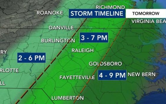
The Storm Prediction Center is warning about the chance for egg-sized hail at least 2 inches in diameter, locally damaging winds up to 75 mph and several strong tornadoes, which could blow at more than 100 mph on Thursday. The threat will be greatest between 2 and 9 p.m., according to Gardner.
“This has the potential to do even more damage than we thought yesterday,” Gardner said.
The system will move closer to the Triangle from the west throughout the afternoon, and conditions could be worst during the evening commute.
Instead of one large system, WRAL meteorologist Zach Maloch said the storms will come in waves beginning Thursday afternoon, and each has the potential to produce life-threatening impacts like EF2 tornadoes.
Level 4 risk is rare in North Carolina
The last time a Level 4 risk was issued in North Carolina was in 2012.
Gardner referenced North Carolina’s worst tornado outbreak to date, which occurred on April 16, 2011, when 30 tornadoes were confirmed across the state. Last month, an EF2 tornado killed three people in Brunswick County near Wilmington.
“I’m not saying that’s what’s going to happen tomorrow, but it’s highly unusual to have a risk level this high,” Gardner said.

It will be especially important to keep devices charged beforehand, have an emergency plan in place for your household and download the WRAL Weather app to receive severe weather alerts.
If there is a tornado warning in the viewing area, WRAL meteorologists will be tracking the storm on air. You can watch on TV or right in the app.

Thursday’s high will be warm, in the mid 70s. The day will begin with cloudy skies, a light breeze and a small chance for showers, then showers and storms will become more likely later in the afternoon and into the evening.
Wednesday will be about 10 degrees cooler, with a high near 63 and just a 20% chance for showers.

There is a 30 percent chance for rain on Friday, and highs will stay around 60 degrees. The weekend looks mostly sunny and dry but colder, with highs in the mid to upper 50s for both Saturday and Sunday.
