Looking back at deadly 2011 tornadoes, Fayetteville prepares for Level 4 risk

Fayetteville, N.C. — Currently under a rare and dangerous Level 4 risk for severe weather, Cumberland County could be among one of the hardest hit areas when thunderstorms arrive late Thursday afternoon.
A Level 4 out of 5 storm risk is extremely rare in North Carolina, according to WRAL meteorologists. The last time the state was under a Level 4 risk a day before the storm system arrived was in 2012.
One year earlier, in April 2011, the Triangle was under a Level 4 risk for severe storms. On April 16, the day of the anticipated severe weather, the risk was upgraded to Level 5.
April 16, 2011, was the last time the Triangle saw multiple tornadoes on the grounds producing damage at the same time.
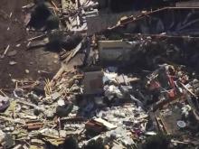
Benjamin Martin Elementary School in Fayetteville was one of many structures that was damaged that day, and WRAL Fayetteville reporter Gilbert Baez recalled seeing the school’s fence littered with the personal belongings of children.
In the tornado outbreak of 2011, houses in nearby communities on Yadkin Road were leveled, and cars were flattened and stacked like pancakes. Residents said the community, located just outside of Fort Bragg, resembled a war zone.
Crystal Brown, who was principal at Benjamin Martin Elementary when the storm struck 10 years ago, said Thursday she’ll never forget that day.
“My first reaction when looking at it was just complete shock,” Brown said. “I mean, I saw all sorts of debris. There was a teddy bear, clothing … everything was just stuck to a fence that was near the school. And of course when you look and you see that part of the roof was gone, it was pretty much a very emotional day for me.”
Since the storm hit on a Saturday, students were not in school. While the building was repaired, students were relocated to a school on Ramsey Street.
Although there is a risk for dangerous weather across central North Carolina on Thursday, Cumberland and Sampson counties are more likely to see strong EF2 tornadoes when storms move into the area after 3 p.m. Crews are on standby to restore power if needed, and schools are operating virtually.
In North Carolina on April 16, 2011, 30 tornadoes were confirmed, with nine occurring in the Raleigh area. Among the nine were two EF-3 tornadoes, four EF-2 tornadoes and three EF-1 tornadoes.
A total of 24 people died in North Carolina, most in Bertie County, and eight people died in the WRAL viewing area, the most in April on record in central North Carolina.
Total structural damage in central North Carolina from the 2011 tornadoes was estimated at more than $300 million.
According to the Enhanced Fujita Scale used to track tornado intensity, EF-2 tornadoes produce wind gusts over 110 mph and EF-3 tornadoes produce gusts over 135 mph. The Level 4 risk in place for Thursday calls for a strong possibility of multiple EF-2 tornadoes, with even stronger storms possible.
Egg-sized hail up to 2 inches in diameter will be possible Thursday along with winds gusts 75 mph or higher. The threat for severe weather is between 2 p.m. and 9 p.m., with the strongest impact expected late afternoon and during the evening commute.
Much more recently, three people were killed when an EF-2 tornado hit Brunswick County in February.
It’s too early to know if the storms will produce weather as deadly as the tornado outbreak in 2011, but WRAL meteorologists will be monitoring conditions morning and night.
It will be especially important to keep phones and other communication devices charged beforehand, have an emergency plan in place for your household and download the WRAL Weather app to receive severe weather alerts.
If there is a tornado warning in the viewing area, WRAL meteorologists will be tracking the storm on air. You can watch on TV or right in the WRAL app.

