- Fake job seekers are flooding the market, thanks to AI
- One set of evacuation orders lifted in Caldwell County after wildfire contained
- 'We gutted every building' | Chimney Rock rebuilding after Hurricane Helene
- 'We gutted every building' | Chimney Rock rebuilding after Hurricane Helene
- Debris from Hurricane Helene provides fuel, complicates containment for spring wildfires
Forecast: Light rain linger tonight; more severe weather possible Friday
AUSTIN, Texas — Another busy weather day across Central Texas with severe storms sweeping through our northern counties. There were many reports of hail as large as baseballs in parts of Mason and Burnet counties. Golf ball size hail was reported in Williamson County.
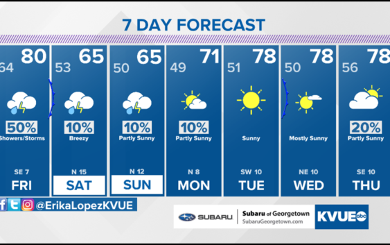
We aren’t completely done with the severe weather threat this week. Friday brings a 50% chance of scattered showers and storms with a “Marginal Risk” for severe weather which is a level 1 out of 5 threat. Large hail and damaging winds will be our primary concern once again.
A cold front will push through Central Texas late Friday. This front will bring a thin line of showers and storms through Central Texas Friday night, but big changes will settle in behind this front for the weekend.
Temperatures turn much cooler with highs only in the 60s both Saturday and Sunday. Rain chances also trend much lower with just 10% chance of spotty rain.
THURSDAY NIGHT:
Cloudy with a 40% chance of showers and storms. East wind at 10 mph.
LOW: 64°
FRIDAY:
Cloudy with a 70% chance of showers and storms. South wind at 5 to 10 mph.
HIGH: 82°
SATURDAY:
Mostly cloudy. 50% chance of showers and storms. East/northeast wind at 10 mph.
HIGH: 66°