- Debris from Hurricane Helene provides fuel, complicates containment for spring wildfires
- David & Nicole Tepper increase Hurricane Helene relief commitment to $750k
- David & Nicole Tepper increase Hurricane Helene relief commitment to $750k
- McDowell County wildfire spreads to 500 acres, evacuation orders in place
- Evacuations in Caldwell County due to wildfire
TIMELINE: Flash Flood Warning for parts of southeast Texas

The KHOU11 Weather team is closely monitoring heavy rainfall that is expected to continue Saturday and early Sunday.
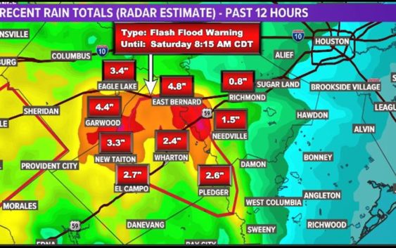
HOUSTON — The National Weather Service issued a Flash Flood Warning for portions of the KHOU11 viewing area. The warning is in effect for west central Brazoria County, southwestern Fort Bend County, north central Matagorda County and northeastern Wharton County until 8:15 a.m.
There’s also a Flash Flood Watch for most of southeast Texas until 7 a.m. tomorrow.
WEATHER ALERTS: Get the KHOU11 mobile app and turn on weather notifications
WEATHER RADAR: Track storms, rain across Southeast Texas
The areas under a Flash Flood Watch until Sunday morning include the following counties/areas covering a portion of Southeast Texas: Austin, Bolivar Peninsula, Brazoria Islands, Chambers, Coastal Brazoria, Coastal Galveston, Coastal Harris, Coastal Matagorda, Colorado, Fort Bend, Galveston Island, Inland Brazoria, Inland Galveston, Inland Harris, Inland Matagorda, Matagorda Islands, Southern Liberty, Waller and Wharton.
The earlier Flash Flood Warning for the Willis, Montgomery and Prairie View areas expired.
Houston weather radar
Timeline: When to expect the heaviest rain, storms in Houston
FRIDAY EVENING: Widespread light rain most of the evening and overnight, but nothing that will cause flash flooding. Be careful on wet roads.
SATURDAY: Our next round of potentially heavy rain arrives before sunrise Saturday morning (4 a.m. – 9 a.m.). An additional 1″ to 3″ of rain is possible in the heavier downpours. After that, things should settle down with only slight rain chances through Saturday afternoon.
SATURDAY NIGHT: Another round of storms is expected to move across the area from west to east. Rainfall could be quite heavy, but this line of storms is forecast to be moving fairly quickly. Fingers are crossed that it will move through without causing too much trouble. However, we could see an additional 1″ to 3″ with this round and with saturated grounds in place, Flash Flooding will be a concern.
SUNDAY: A few lingering scattered showers through the morning. Then, improving conditions, maybe a peek of sunshine by late afternoon.
NEXT WEEK: We’ll finally start to see some sunshine come Monday as temps heat up to about 90 degrees.
We are 6+ inches behind in our rainfall. So all this rain will be beneficial in tamping down the expanding drought conditions across Southeast Texas.