- Charlotte-based marketing agency announces $20,000 Creative Campaign Grant to help communities after Hurricane Helene
- Artists transform hurricane aftermath into hoop-inspired masterpieces at Charlotte exhibit
- NC's cost for Hurricane Helene damage is nearly $60 billion, state says
- State to develop drone program to better respond to disasters like Helene, Florence
- South Carolina residents face deadline to get storm debris out to the curb after Hurricane Helene
Panovich: Severe weather likely Tuesday across Charlotte area

A line of strong thunderstorms will bring the threat of damaging winds, hail, heavy rain and isolated tornadoes to the Charlotte region Tuesday afternoon.
CHARLOTTE, N.C. — The Charlotte area will again be at risk for severe weather as a line of thunderstorms will move into the Carolinas Tuesday afternoon.
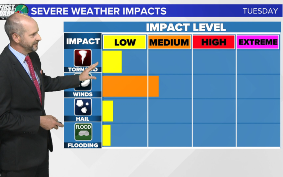
First Warn chief meteorologist Brad Panovich says Tuesday’s storm setup is much more straightforward than Monday’s clusters, with a clear line forming ahead of a cold front that’s pushing east toward the Atlantic coast. Currently, the Charlotte area is at “low” risk for severe weather, but Panovich said that could easily be upgraded.
“The air mass ahead of this front is unstable already. Warm and humid air is creating a favorable environment for severe weather,” Panovich said. “Don’t be surprised if we upgrade to medium risk. Because of the way this is shaped, like a bow and arrow, we call it a ‘bow echo,’ this, to me, has straight-line winds risk written all over it. Typically, we tend to see straight-line winds with that bow and arrow shape on the radar.”
Panovich expects the line of storms to move into the North Carolina mountains by around 1 p.m. Areas like Asheville, Boone, Blowing Rock and Hendersonville will be among the first to get hit.
By 3 p.m., the storms will move over the foothills and Piedmont, approaching Charlotte. All areas from Shelby, Lincolnton, Gastonia, Hickory, Huntersville, Charlotte, Mooresville, Concord, and Albemarle in North Carolina will be impacted. These storms will also affect South Carolina cities like Fort Mill, Rock Hill, Chester and Lancaster.
Panovich said there’s no “overwhelming” threat of tornadoes, but you can never rule out the possibility of rotating storms during severe weather.
“There’s thunderstorm fuel in the atmosphere,” Panovich said. “Because there’s time to build ahead of the storms, that increases our risk. We’re looking at 2,000 to 3,000 CAPE. Anything 1,000 or higher, that’s when you start to pay attention, 2,000 is a legit chance and anything above that, you’re talking about significant severe weather risk.”
Most of the Charlotte area was spared by significant damage during Monday’s storms. Severe winds appeared to top a truck near Oakboro in Stanly County, according to social media pictures shared with Brad Panovich.
Those strong winds that blew through Stanly County also caused trees to be completely uprooted — some crashing into parts of homes, along with damage to metal carports, barns, and blown-off roofing.
Severe weather earlier Monday left damage behind in Georgia as it moved eastward into the Carolinas.
Tuesday will see another threat of strong storms in the afternoon. Panovich said the current setup looks like what’s known as a “bow echo,” which can have supercells embedded along a line of storms.
RELATED: What is a bow echo?
If you find yourself inside a tornado warning, you should immediately seek shelter inside a sturdy structure. Inside that structure, you want to find the most interior room on the lowest level of the structure. Basements are most ideal but in buildings without basements, you could consider an indoor closet, bathroom, or any interior room.
You should be sure to protect your head with a helmet or pillow. When entering the shelter, you should ideally be wearing shoes and pants. In the event you encounter damage when exiting your shelter, the clothing could help protect you against storm debris.
Contact Brad Panovich at bpanovich@wcnc.com or follow him on Facebook, Twitter and Instagram.
Contact Briana Harper at bharper@wcnc.com and follow her on Facebook, Twitter and Instagram.