- $37M drainage improvement project designed to combat flooding in NE Harris County
- Temporary bridges in Avery County at risk due to severe weather threat
- FEMA extends aid as Hurricane Helene recovery efforts surpass $360M
- Nearly every North Carolina wildfire caused by people, researchers say
- Weather IQ: How do wildfires ignite?
Tornado warning issued for Orange County, severe thunderstorm watch issued for Triangle
A tornado warning has been issued for Orange, Chatham and Alamance Counties until 5:15 p.m.

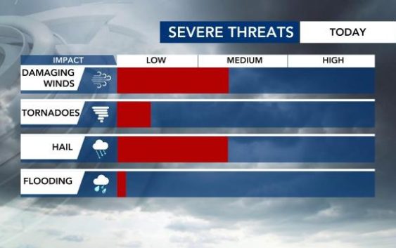
The threat for severe weather in the WRAL viewing area grew overnight, and part of the Triangle is now in the level 2 risk area. The level 2 threat is in effect for Raleigh, Fayetteville, much of the Sandhills region as well as east of Interstate 95.
A severe thunderstorm watch has been issued until 10 p.m. for many counties in the WRAL viewing area, including the Triangle.
We’ll start out warm and have a chance of showers during a humid and wet morning. Temperature-wise, Fayetteville was already at 70 degrees before sunrise while Raleigh and Durham were at 62.
A long line of showers and storms will impact us on-and-off during the day. Strong winds and hail are possibilities.
“I wouldn’t expect any severe weather this morning,” WRAL meteorologist Elizabeth Gardner said. “We’ll get a little break midday and then see another round that comes through this afternoon.”

We should see a slight break in rain coverage with the sun popping out slightly. Temperatures will climb into the mid-to-upper 70s for most with areas to the south like Fayetteville and Clinton sneaking into the 80s.
The storms are likely to arrive in the afternoon. Gardner says they’ll begin to pop up after 1 p.m. and can increase in coverage and intensity through the evening commute.

“By early-to-mid afternoon, we’re starting to see some storms that pop up across our area,” Gardner said. “This line of storms is going to be with us for a while. It starts early afternoon and it doesn’t really taper off until closer to midnight.”

The cold front that brings us the thunderstorms will also cool us down.

“This will be the last warm day for a while,” WRAL meteorologist Aimee Wilmoth said. “After Tuesday, we stay in the 60s for our highs through Friday. There’s some cool air back behind that front that’s coming through this afternoon.”
We’ll be drier Tuesday for the Durham Bulls Opening Day coverage. No problems there! Isolated rain chances will be rather sporadic Wednesday to Friday and are dependent on the strength of an area of high pressure as that can keep a lot of that rain south.
