- Artists transform hurricane aftermath into hoop-inspired masterpieces at Charlotte exhibit
- NC's cost for Hurricane Helene damage is nearly $60 billion, state says
- State to develop drone program to better respond to disasters like Helene, Florence
- South Carolina residents face deadline to get storm debris out to the curb after Hurricane Helene
- SCDOT to pick up Hurricane Helene debris for a final day in South Carolina
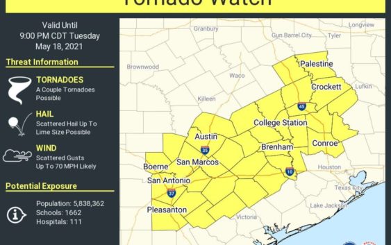
San Antonio now under a tornado watch as severe storms roll through the area

Update: A tornado watch has been issued for San Antonio until 9 p.m. Tuesday. According to the National Weather Service, a couple of tornadoes are possible along with hail that has the potential to be as large as limes. Wind gusts of up to 70 mph are also likely.
Update: A Severe Thunderstorm Warning has been issued for parts of Bexar County until 2:45 p.m., according to the National Weather Service.
The area for the alert includes Fair Oaks Ranch, Scenic Oaks and Bulverde.
Radar shared by the NWS on social media showed “very heavy rain plus gusty winds and nickel sized hail.” Forecasters warn that “motorists can expect reduced visibility and water covered roadways.”
Original story:
San Antonians should prepare for another day packed with rain and storms.
According to the National Weather Service, the San Antonio area could see between six to eight inches of rain by Thursday.
Meteorologist Bob Fogarty says the best chance for storms and heavy rain will be Tuesday and Wednesday. The National Weather Prediction Center has issued a slight to moderate risk for flooding for most of the area.
Forecasters are also monitoring and preparing for river flooding. The West Gulf River Forecast Center tweeted they will be focusing on an area from Dallas all the way down to the San Antonio area.
“Forecast rainfall will impact area lakes. Water supply reservoirs will coordinate their releases, flood control/mitigation reservoirs will hold releases and coordinate with WGRFC forecasters.”
Fogarty says one area they will be watching closely is the Guadalupe River.
READ ALSO: It’s snake season, y’all: Here are the top 5 snakes you’ll find in San Antonio
Bexar County remains under a Flash Flood Watch remains until 1 p.m. on Thursday.
Storms could also bring hail and damaging winds, Fogarty says.
As far as a timeline goes, the NWS says “storms will move across South Central Texas today and again later tonight into early Wednesday morning.”
According to the NWS, San Antonio will likely see rain continue through the weekend.
So what is causing so much rain to hit San Antonio?
Fogarty says there is a big upper level low to the west plus there is tons of moisture in the air right now.
Storms from Monday night led to outages with CPS Energy crews working on getting customers back up early this morning.
“Our crews are working to restore less than 9k customers who are experiencing an outage due to last night’s weather, which brought strong winds & gusts of up to 45mph,” the energy company tweeted.
They also want customers to know they will be monitoring the weather today as more storms are expected.


