- Cast of Scandal reunites to show support for western North Carolina after Hurricane Helene
- Tropical Storm Sara threatens to bring flash floods and mudslides to Central America
- Hurricane-stricken Tampa Bay Rays to play 2025 season at Yankees' spring training field in Tampa
- Utah scores 3 goals in 2 1/2 minutes in 3rd, Vejmelka has 49 saves in 4-1 win over Hurricanes
- Driver dies after crashing off hurricane-damaged highway in North Carolina
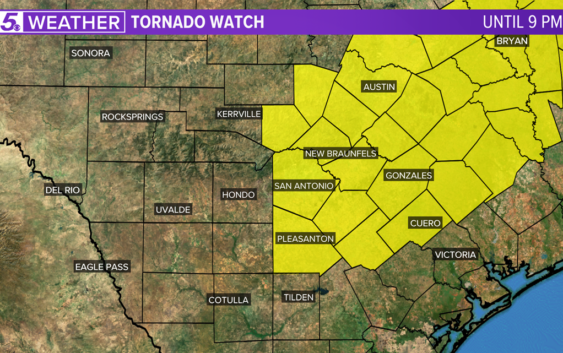
KENS 5 Weather: Tornado Watch in effect for Bexar County and I-35 corridor

Follow KENS 5 on air and online for breaking severe weather coverage. Get the KENS 5 app for alerts when severe weather threatens South Texas.
SAN ANTONIO — The National Weather Service has issued a Severe Thunderstorm Warning for portions of Comal and Hays counties until 3:45 p.m. Quarter size hail and 60 mph wind gusts are possible with this storm as it moves east.
A Significant Weather Advisory includes Guadalupe and Wilson Counties. This thunderstorm may produce nickel size hail and 50 mph wind gusts.
A Severe Thunderstorm Warning including the north and northwest parts of San Antonio has been issued until 2:45 p.m.
The National Weather Service has issued a Tornado Watch for Bexar County and many other counties in the I-35 corridor and eastward. The watch is in effect until 9 p.m. Tuesday.
The National Weather Service issued a Flash Flood Watch that went into effect at 7 p.m. on Monday. It includes: San Antonio, Boerne, New Braunfels, Kerrville and surrounding areas.
The Flash Flood Watch will be in effect until Thursday afternoon.
On Tuesday and Wednesday, there is a good chance that some storms could be severe.
With many chances for rain over the next seven days, south central Texas could receive an additional 3” to 4” of rain.
With saturated soil, there is a chance for some flash flooding this week, especially Wednesday.
The atmosphere becomes tropical Friday through the weekend, so the threat for severe storms goes away, but there will be a chance for some heavy downpours.
This is a developing weather event. Refresh the page for the latest updates.
SEVERE WEATHER 101
When severe weather threatens the area, it is important to know what risks a storm can bring and what you should do to stay safe.
One of the most important things to know is where you are located on a map, so when a watch or warning is put into place, you can identify if you are at risk. When the National Weather Service puts out warnings, they are county-based and sometimes include cities as well. It is important to know where you live in the county and that you can identify it on a map.
It is also important to know the difference between a watch and a warning. A watch means that conditions are favorable for something to happen, but a warning means that something has developed and it is important to take action.
So, what would cause a thunderstorm to be qualified as a “severe” thunderstorm?
Hail that is one inch large is also considered to be about the size of a quarter.
Another ingredient that would lead to a storm becoming severe is if winds are 58 mph or greater.
Winds at this strength could cause damage to roofs and could even cause trees to be knocked down.
Finally, if a tornado is present inside a thunderstorm it would qualify the storm as becoming severe.
In this instance, a tornado warning would be issued.
A tornado watch can be issued for an area if strong storms are expected, and if the storms bring the risk for tornadoes, but not all storms include the threat for tornadoes. The ingredients in the atmosphere for a tornado to form are not always there when storms are present.
If the area you are in is ever under a tornado warning, it is important to know where you should go inside your home.
Head to the lowest, interior room of your home. The basement would be best, but if you don’t have one, head to the first floor of the home and get away from exterior walls, or walls that lead to the outside of the home.
It is also important to stay away from glass. The more walls you can put between you and the outside, the better.
While lightning can be frequent in storms and very dangerous, it does not lead to a storm being qualified as severe.
Remember, when thunder roars, go indoors.
Storms can also lead to flooding. Flooding may not cause a storm to be labeled as being severe, but it is the deadliest kind of weather.
South Texas is known to have major flood events every few years, so it is important to use caution and to always stay out of floodwaters. Remember, turn around, don’t drown.
Entering flood water is very dangerous as you can be swept off of your feet and you don’t know what could be in the water that could hurt you.
The best thing you can do to be ready for severe weather is know what you will do in the event it strikes where you live.
Make sure your family has a severe weather action plan.
Have a place everyone goes inside your home and keep supplies there, such as food, medication, batteries, and flashlights.
Weather Minds Classroom: Take a class in Severe Weather 101
Follow the KENS 5 Weather Team
Don’t forget you can download the KENS 5 app for the latest news and weather information each day while you are on the go.