- The White House's Christmas tree is a symbol of resilience for hurricane-hit North Carolina farms
- Hurricane Helene isn't the only big storm North Carolina is still recovering from
- Warm winter ahead: WRAL Severe Weather outlook doesn't look good for snow lovers
- Recovery continues for western NC nearly two months after Hurricane Helene
- Recovery continues for western NC nearly three months after Hurricane Helene
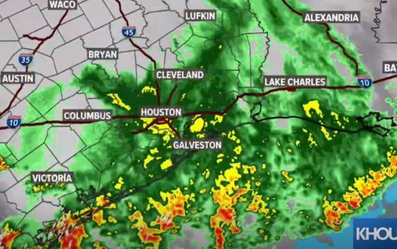
LIVE RADAR: Break from the heavy rain for now — Flash Flood Watch continues

A Flash Flood Watch continues for all of our region until early Thursday afternoon.
HOUSTON — Strong storms moved through southeast Texas Tuesday, bringing with them strong wind, heavy rain and plenty of lightning. And the severe weather threat continues this morning as well.
Wednesday morning, we have more widespread downpours and thunderstorms moving through from west and southwest of Houston. The good news is currently, there are no widespread reports of street flooding in Houston as of 7:35 a.m.
TRAFFIC MAP: Look for reported incidents on your morning commute
WEATHER MAP: Track the rain & storms on our interactive radar map
Active watches and warnings in our area:
The National Weather Service in League City has extended the Flash Flood Warning for Jackson County in south central Texas and West Central Matagorda County in southeastern Texas until 11:30 a.m. Wednesday. Doppler radar indicated thunderstorms produced heavy rain across the warned area. Between 3 and 5 inches of rain have fallen. Flash flooding is ongoing, and continuing light rain is prolonging the time needed for water to recede
A Flash Flood Watch is in effect for the following counties through Thursday morning: Austin, Brazoria, Chambers, Galveston, Harris, Jackson, Matagorda, Colorado, Fort Bend, Grimes, Montgomery, Liberty, Polk, San Jacinto, Trinity, Walker, Waller, Washington and Wharton Counties.
Earlier Severe Thunderstorm and Tornado Warnings have expired.
CURRENT WATCHES & WARNINGS: You can check all watches and warnings here
What’s next
KHOU 11 Chief Meteorologist David Paul said Tuesday night’s storms moved quickly, which helped to keep our bayous and streams within their banks. We will still have to watch today’s rain, however, as the showers are now more slow-moving, and the ground is very saturated.
KHOU 11 Meteorologist Chita Craft says this current round of storms and moderate to heavy downpours will start to clear after 9 a.m. Wednesday.
Watch her latest update here:
We can expect to continue to get scattered showers throughout the day Wednesday and through Thursday morning before the rain chances let up a little. While it won’t be as bad, we will still have clouds and a chance of scattered showers and storms through the weekend. Unfortunately, we don’t have any really nice sunny days in the forecast anytime soon.
Power outages
CenterPoint Energy is reporting power outages across the Houston area. Click here to see the map. As of 8:35 a.m. Wednesday, there were over 17,000 customers without power.
Lightning caught on video
How much rain are we talking?
Currently, our greatest concern is street flooding, especially in areas that get the worst of Wednesday’s downpours. We are not expecting widespread flooding in homes or structures, but those who live in very low-lying areas or areas with draining issues will want to keep a close eye on the radar. Either way, the rain is going to make for a nasty commute Wednesday. Remember, turn around – don’t drown. If you can’t see the bottom of the roadway, don’t assume you know how deep the water is.
What to do during a Tornado Warning
People within the affected area should seek shelter immediately and take action. The warning means there is an imminent danger to life and property. Here are some tips:
- Get In: Get inside a sturdy structure, find shelter in an interior room, away from windows.
- Get Low: Seek shelter on the lowest floor possible, or underground, if possible.
- Hold On: Grab on to a sturdy object and hold on.