- Hurricane Helene isn't the only big storm North Carolina is still recovering from
- Warm winter ahead: WRAL Severe Weather outlook doesn't look good for snow lovers
- Recovery continues for western NC nearly two months after Hurricane Helene
- Recovery continues for western NC nearly three months after Hurricane Helene
- Cast of Scandal reunites to show support for western North Carolina after Hurricane Helene
Weather Timeline: More Thunderstorms possible this afternoon; flash flood watch continues

If you need to get out today, your best bet is to do it as early as possible. By early afternoon, we could see another round of thunderstorms push through.
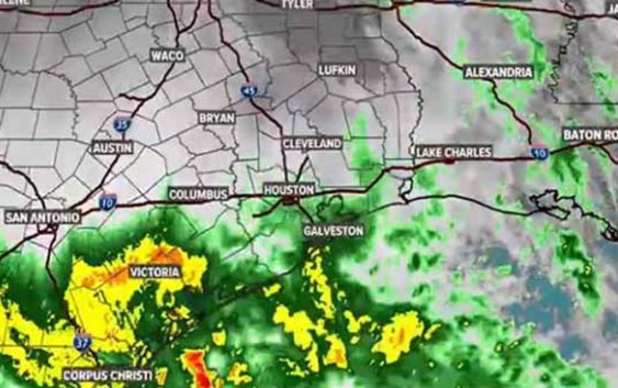
HOUSTON — We’re getting a brief break from the heavy rain after strong storms moved through Southeast Texas late Tuesday and early Wednesday, bringing strong wind, heavy rain and plenty of lightning.
The entire area remains under a Flash Flood Watch through Thursday morning.
If you need to get out today, your best bet is to do it as early as possible. By this afternoon, we could see another round of thunderstorms push through, according to KHOU 11 Meteorologist Addison Green. The threat goes up from there.
Weather timeline
Light showers could turn into moderate thunderstorms this afternoon. The storms could increase in intensity through the afternoon hours with the highest threat this evening between 5 p.m. and 7 p.m.
Fort Bend and other southern counties would likely see the heavier stuff first. Fort Bend County Emergency Management said there is no flooding threat, at this time, but they’re keeping a close watch on the Brazos River — just in case.
“Currently, right now, there are no major concerns with it but, as you can see, it’s up more than it has been in the last six months,” they said in a news conference.
Right now, widespread flooding is not a threat, but there could be isolated pockets of heavy rain, so stay weather aware.
Active watches and warnings in our area:
The National Weather Service in League City has extended the Flash Flood Warning for Jackson County in south central Texas and West Central Matagorda County in southeastern Texas until 1:30 p.m. Wednesday. Doppler radar indicated thunderstorms produced heavy rain across the warned area. Between 3 and 6 inches of rain have fallen. Flash flooding is ongoing, and continuing light rain is prolonging the time needed for water to recede.
A Flash Flood Watch is in effect for the following counties through Thursday morning: Austin, Brazoria, Chambers, Galveston, Harris, Jackson, Matagorda, Colorado, Fort Bend, Grimes, Montgomery, Liberty, Polk, San Jacinto, Trinity, Walker, Waller, Washington and Wharton Counties.
Earlier Severe Thunderstorm and Tornado Warnings have expired.
CURRENT WATCHES & WARNINGS: You can check all watches and warnings here
What’s next in the 7-day
The rain chances will decrease for the weekend, but we could still see scattered showers and clouds. We’ll finally start to dry out by Sunday with nicer weather by Monday.
Watch KHOU 11 Meteorologist Addison Green’s latest update here:
Power outages
CenterPoint Energy is reporting power outages across the Houston area. Click here to see the map. As of 11:20 a.m. Wednesday, there were over 11,000 customers without power.
Lightning caught on video
What to do during a Tornado Warning
People within the affected area should seek shelter immediately and take action. The warning means there is an imminent danger to life and property. Here are some tips:
- Get In: Get inside a sturdy structure, find shelter in an interior room, away from windows.
- Get Low: Seek shelter on the lowest floor possible, or underground, if possible.
- Hold On: Grab on to a sturdy object and hold on.