- Cast of Scandal reunites to show support for western North Carolina after Hurricane Helene
- Tropical Storm Sara threatens to bring flash floods and mudslides to Central America
- Hurricane-stricken Tampa Bay Rays to play 2025 season at Yankees' spring training field in Tampa
- Utah scores 3 goals in 2 1/2 minutes in 3rd, Vejmelka has 49 saves in 4-1 win over Hurricanes
- Driver dies after crashing off hurricane-damaged highway in North Carolina
Gulf weather update: System has 60% chance of development with heavy rainfall, potential for flooding, NOAA says

Southeast Texas is already saturated so more heavy rain could lead to flash flooding across the region, according to the National Hurricane Center.
HOUSTON — KHOU 11 Meteorologist Blake Mathews is closely watching a tropical disturbance in the Gulf of Mexico that is already bringing more showers to our region.
The well-defined system, now called invest 91L, is not a tropical storm or a hurricane. Currently, it has a 60% chance of further development into a depression or actual named storm, but Mathews says it is running out of time to do that as it races to the Texas coast.
Invest 91L is expected to head toward the Corpus Christi area, but that will put the Houston region on the wet side.
“Regardless of development, the system could produce heavy rainfall over portions of southeastern Texas and southwestern Louisiana through Saturday,” NOAA says.
Southeast Texas is already saturated so more heavy rain could lead to flash flooding across the region, according to the National Hurricane Center.
Blake Mathews points out that Houston’s grounds are already very saturated due to this week’s storms, so we will want to watch any heavy downpours very closely.
Will it flood in Houston?
“We can absorb another three to five inches of rain, it’s the five to ten inches that we would have a problem with,” said Mathews. “The National Hurricane Center has increased the chance of development in the Gulf to 40% over the next two days. We standby what we’ve said before: even if it becomes a storm, impacts on Texas will be fairly minimal aside from heavy rain.”
For now in Houston, your drive home this evening could be wet. Expect wet weather with scattered downpours Friday night and through Saturday before we get a bit of a break on Sunday.
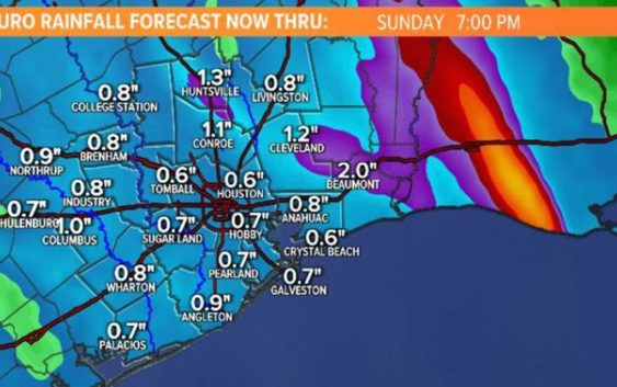
As of Friday afternoon, NOAA’s three-day rain totals map showed that most of the Texas coast from Corpus Christi to Beaumont and Orange can expect about an inch of rain overall over the next 72 hours. That is a decrease from earlier models that had some areas getting perhaps three inches of rain.
Under normal circumstances we wouldn’t have to worry much about an inch or so of rain, but Houston’s grounds are already very saturated from the storms earlier this week. We’ll want to keep an eye out for any isolated areas of street flooding if any storms or downpours linger.
Blake Mathews says our bayous currently are about half full, so we still have room to take on the additional rain. He also says the good news is the Gulf system appears to be fast-moving.
He says there is currently no flood watch in place.
Houston 7-day forecast
Hope you weren’t hoping for a sunny weekend after all of the rain we’ve had already.
Scattered rain is likely from Corpus to Louisiana
On Thursday, the National Weather Service said they expect heavy rain anywhere from Corpus Christi and areas east into southwestern Louisiana, the wet side of the system.
Even without widespread concerns of flooding, if you have outdoor plans for outside this weekend, you’ll want to have a backup plan for indoors.