- Austin adopts new map that greatly expands area at risk of wildfire
- CenterPoint Energy accelerates infrastructure improvements ahead of hurricane season
- Carolina Hurricanes playoff tickets go on sale Thursday
- Ask the Meteorologist: Why do tornadoes target Tornado Alley, Dixie Alley?
- Nonprofit closes distribution site that aided thousands after Hurricane Helene
Flash flood watch issued as another rainy evening possible
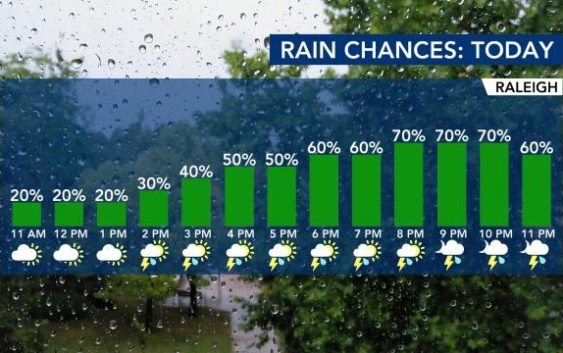
Raleigh, N.C. — Scattered showers and thunderstorms are back on tap Friday in central and eastern North Carolina.
“We’ll see scattered showers and storms pop up this afternoon and stay with us through the evening commute,” WRAL meteorologist Zach Maloch said. “If you have any dinner plans outdoors, just know to grab the umbrella.”
Highs Friday are expected to be in the low 80s.
Storms are possible through the evening and into the early hours of Saturday, and pockets of heavy rain are possible, WRAL meteorologist Aimee Wilmoth said. Northeast counties are under a flash flood watch through the evening, she said.

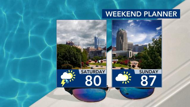
Showers could continue Saturday, Wilmoth said, but they won’t be as widespread as Thursday or Friday. Highs will be in the upper 70 to low 80s.
The rain chances drop to 20 percent on Sunday, but it will still be humid, with highs in the upper 80s, she said.
Meteorologists also are keeping an eye on a system in the Pacific, Wilmoth said. If it crosses the Bay of Campeche and emerges in the Gulf of Mexico on Sunday, it has a 20 percent chance to develop into a tropical system in the following five days.