- Residents evacuate as wildfire rapidly spreads in South Bexar County
- Duke Energy prepares for potential power outages as severe weather nears the Triangle
- South Carolina wildfire grows to more than 2,000 acres, firefighters concerned about strong winds Tuesday
- Roof ripped off, damaged apartments, flipped over RVs: The DFW storm damage we saw
- Firefighters concerned about winds picking up Tuesday as South Carolina wildfire grows to more than 2,000 acres
Tropical Storm Claudette expected to bring heavy rain to North Carolina Monday
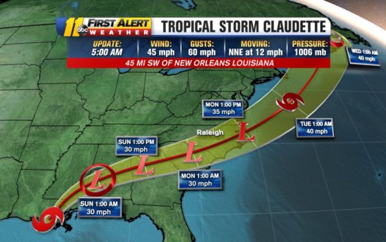
RALEIGH, N.C. (WTVD) — After bringing life-threatening flash flooding to the Gulf Coast, Tropical Storm Claudette will be moving quickly toward North Carolina Sunday.
First Alert Meteorologist Steve Stewart said the system could be arriving in the state as early as Monday morning.
There will be rain throughout the state Sunday way ahead of the storm.
Rain could be heavy at times and there could be a threat for an isolated tornado early Monday morning.
Right now, the severe risk is for those south and east of the Triangle, however, paths can change.
Tropical Storm Claudette will be heading towards North Carolina quickly tomorrow and arriving early Monday morning. Rain could be heavy at times and the threat for isolated tornadoes early Monday. It will increase forward speed, so Monday PM will be drying out but hot. pic.twitter.com/nJ3zeR7ut8
— Steve Stewart (@StewartABC11) June 19, 2021
By Monday afternoon, the state will be drying out and hot.
As of 5 a.m., the system is moving north-northeast at 12 mph with maximum sustained winds of 45 mph and gusts up to 60 mph.
Copyright © 2021 WTVD-TV. All Rights Reserved.