- Right-wing political activists call for NC lawmakers to decide 2024 presidential election results after Hurricane Helene's impact
- Grove Park Inn cancels National Gingerbread House Competition for 2024 due to Hurricane Helene devastation
- Trump makes more debunked claims about FEMA as he surveys storm damage in North Carolina
- Hundreds rescued, sheriff stranded on truck roof after deadly flooding in New Mexico
- In North Carolina, Trump and Harris navigate a hurricane and a rollercoaster governor’s race
More heat, tropical storm conditions possible with Elsa beginning Wednesday night
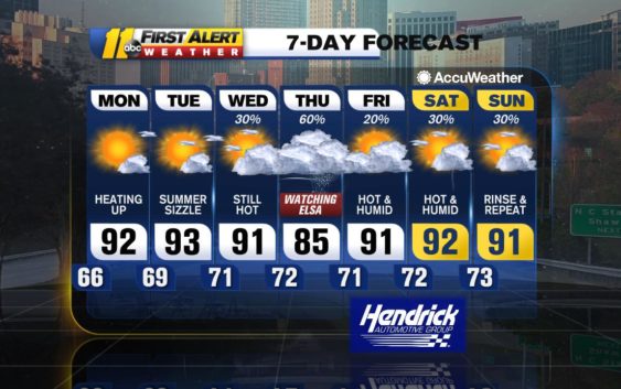
RALEIGH, N.C. (WTVD) — TUESDAY: High pressure will continue to extend over the Carolinas. Expect mainly sunny skies with highs in the low 90s. It will feel like the mid 90s with increased humidity. Overnight lows will be in the upper 60s and low 70s. Rain chances will remain low. Aside from a stray shower/storm Tuesday, the mainly dry trend will continue.
WEDNESDAY: Moisture will gradually begin lifting into the region ahead of Elsa. Expect intervals of clouds and sunshine in the morning Wednesday, with more clouds later in the day. A stray shower or thunderstorm will be possible. Highs will be near 90. Scattered showers will be possible Wednesday night. Lows will be in the upper 60s and low 70s.
ELSA: The system held together pretty well over Cuba. It’s now over the Florida Straits. Our main impact day will be Thursday. Early indications are that the system’s center will pass just east of the Triangle.
HERE’S THE LATEST OVERVIEW:
-Rainfall looks to be the biggest impact, with the highest totals expected to be from
the Triangle and east. Totals could be anywhere from 0.25-1″ north and west, and
1-3″ from the city on south and east with localized higher amounts of 4-6″ possible
-There will be an isolated risk of severe storms
-Winds will range from 15-25+ mph, with higher gusts near 39+ mph
-Expect the rip current threat to increase
– Highs will be in the upper 70s and low 80s.
**Any shift in track will impact this early-look forecast**
FRIDAY AND SATURDAY: Elsa will lift northeast of the region, but a cold front will remain just west of the region. This along high pressure over the Atlantic will support isolated to scattered showers and storms, mainly afternoon. Highs will be in the low 90s with lows in the low 70s.
Have a great day!
Kweilyn Murphy
Copyright © 2021 WTVD-TV. All Rights Reserved.