- Charlotte-based marketing agency announces $20,000 Creative Campaign Grant to help communities after Hurricane Helene
- Artists transform hurricane aftermath into hoop-inspired masterpieces at Charlotte exhibit
- NC's cost for Hurricane Helene damage is nearly $60 billion, state says
- State to develop drone program to better respond to disasters like Helene, Florence
- South Carolina residents face deadline to get storm debris out to the curb after Hurricane Helene
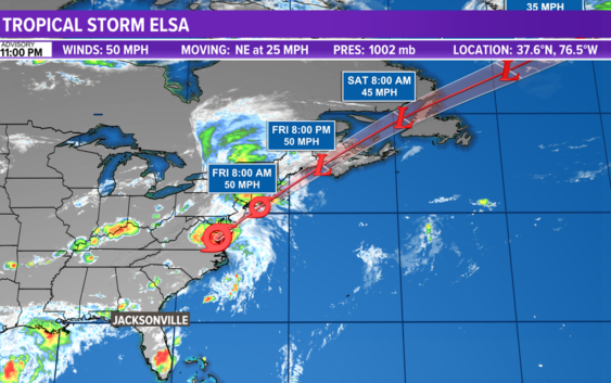
Elsa moving quickly across the Delmarva toward Delaware Bay; Flash flooding for the Northeast

Elsa will continue to lose its tropical characteristics as it moves across the New England states and pushes offshore Friday night.
JACKSONVILLE, Fla. — As of 5 a.m. Friday: Elsa has moved away from the First Coast, but will continue to bring a flash flooding threat to the New England region on Friday.
NHC Discussion: It appears that the early stages of extratropical transition have begun with Elsa, with almost all of the deep convection north of the center. A shortwave moving out of the Great Lakes should cause the storm to deepen on Friday but also expand in size, resulting in the maximum winds staying about the same as they are now. Elsa should transition into an extratropical cyclone within 24 hours due to the shortwave and cold waters south of New England, and then gradually weaken over Atlantic Canada and northeast of Newfoundland after it loses its baroclinic support. The new intensity forecast is similar to the previous one and the consensus of the global models.
The storm is moving faster to the northeast this evening and will gradually accelerate northeastward during the next day or two due to speedy mid-latitude southwesterly flow ahead of a broad mid-tropospheric trough over the eastern North America. Elsa should move over southeastern New England and Atlantic Canada within the next 12-36 hours. The model guidance remains tightly packed on that solution, and the new official track forecast remains close to the previous one.
DID YOU KNOW? Elsa is the earliest-known fifth named storm on record for the Atlantic basin in the satellite era (1966-present), breaking the record formerly held by Edouard on July 6, 2020.
Elsewhere across the Atlantic basin, there is no development expected. Computer models hint at quiet conditions for at least the next 10 days.
Hurricane season is already here and it’s time to be prepared if you aren’t already. Make sure you have had conversations with your loved ones about what you would do if a storm were to threaten.
This year, NOAA released the new seasonal averages for the Atlantic basin. According to the 30-year data from 1991 to 2020, the new averages include 14 named storms, 7 hurricanes, and 3 major hurricanes. The previous Atlantic storm averages, based on the period from 1981 to 2010, were 12 named storms, 6 hurricanes, and 3 major hurricanes. The averages from 1951-1980 , were 11 named storms, 5 hurricanes, and 1 major.
Hurricane safety and preparedness are critically important before the season begins on June 1. NOAA’s National Weather Service provides resources to prepare for hurricane hazards and real-time updates about active weather systems from the National Hurricane Center at www.hurricanes.gov.
The Atlantic hurricane season officially runs from June 1 to November 30.
Download the First Coast News app and sign up for severe weather alerts