- Right-wing political activists call for NC lawmakers to decide 2024 presidential election results after Hurricane Helene's impact
- Grove Park Inn cancels National Gingerbread House Competition for 2024 due to Hurricane Helene devastation
- Trump makes more debunked claims about FEMA as he surveys storm damage in North Carolina
- Hundreds rescued, sheriff stranded on truck roof after deadly flooding in New Mexico
- In North Carolina, Trump and Harris navigate a hurricane and a rollercoaster governor’s race
Late-season front brings 'marginal risk' for severe weather to eastern Central Texas
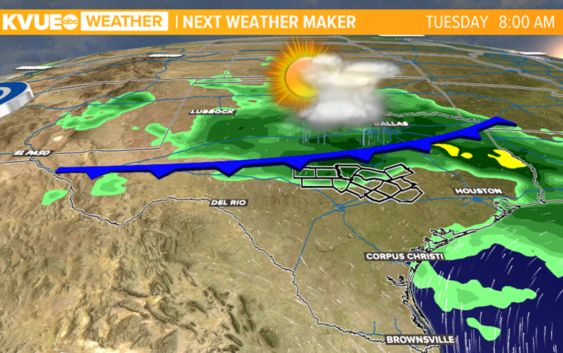
After a mainly dry and seasonably hot weekend, more rain is on the way.
AUSTIN, Texas — After a small break from wet weather, eastern counties in Central Texas are now under a “marginal risk” — one out of five — for severe weather. Strong winds and locally heavy rain are the main concerns for Monday afternoon and evening.
This year in Austin currently ranks as the 12th wettest July on record with 3.95 inches of rain recorded at Camp Mabry. We still have half of the month left, so chances are likely that we could make it to the top 10.
We experienced a break from the rain this weekend with plenty of sunshine and temperatures around seasonal averages. This past weekend was the hottest of the month. With no rain recorded at Camp Mabry, it was our first rain-free weekend in July.
Saharan dust responsible for the weekend haze and allergies is expected to settle down throughout Monday. Air quality has already seen an improvement for Central Texas.
Monday starts warm and humid with some clouds. It’ll be dry for the first half of the day with highs in the 90s. A late-season front arrives late Monday into Tuesday. This increases rain chances as early as Monday afternoon.
Tuesday likely has the highest rain and storm chances, but scattered rain will continue through Friday. With more clouds and rain, afternoon highs will drop to the mid- and upper 80s for the middle of the week.
Rainfall totals could range from a half inch to one and a half inches for much of Central Texas over the next seven days. This is not enough to bring any widespread flooding concerns to Central Texas, but keep in mind that brief moments of heavy downpours will be possible next week, which could result in some minor localized flooding or ponding on roads. It is worth noting that some forecast models indicate the possibility of isolated areas receiving up to three inches of rainfall over the coming week. This is due to our late-season front likely stalling south of I-10.
The KVUE Storm Team will continue to monitor this developing forecast.
In the meantime, the extended forecast can be found below:
PEOPLE ARE ALSO READING: