- Teen thrown from home during EF-2 tornado takes first steps in ICU — with a surprise message from Shaq
- Tennessee restores 46 out of 49 roads post-Hurricane Helene
- Duke Energy boosts storm readiness with technology ahead of hurricane season
- Acting head of FEMA told staff he was previously unaware the US has a hurricane season; DHS said he was joking
- What Texas lawmakers did after the state’s largest wildfire
A 65% chance of an above normal hurricane season. Why the Atlantic is waking back up.

It was a nice break while it lasted! Since Elsa dissipated July 9th, we have enjoyed a nice 3.5 week break from new tropical systems developing. Saharan dust helped to limit tropical development in the main development region which is common for June and July. The Atlantic is waking back up as we head into August.
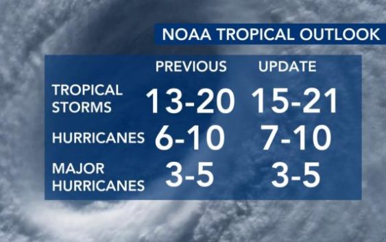
Atlantic hurricane season is most active August through October, so it is usual to see tropical activity pick back up during this time. NOAA released their updated hurricane season outlook today and they are maintaining their forecast of an above normal hurricane season. There is a 65% chance we will see an above normal season and only a 10% chance of a below normal season.
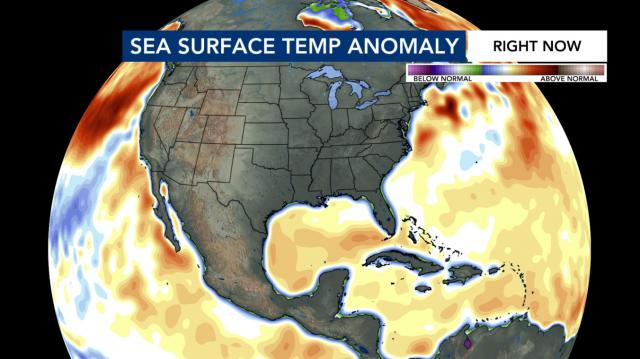
The good news is that this year’s season is not likely to be as active as last year when there were 30 named storms. So far, we have had 5 named storms in 2021. At this point in last year’s record smashing season we already had reached our 9th, Isaias, which impacted NC. The sea surface temperatures are not as warm as they were last year and this is a good thing because warmer temperatures help strengthen and feed tropical systems.
Why so active then? Two main reasons. One is that there is likely to be increased west African monsoon activity this which helps plant seeds for low pressure systems to develop as they first enter the Atlantic off the coast of Africa. In fact, we’re already monitoring one of those waves over Africa right now for possible development.
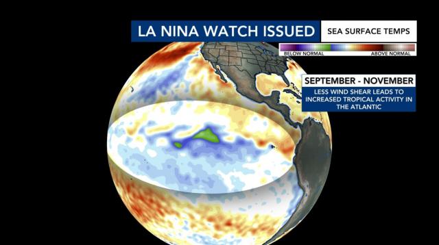
The second reason is a possible transition from neutral to La Nina conditions later this summer. A La Nina Watch has been issued due to this possibility. La Nina years are associated with decreased wind shear in the Atlantic basin. With less wind shear to disrupt or tear systems apart, it is easier for tropical systems to develop and strengthen.
The bottom line is all signs point to an active season so don’t let your guard down despite the brief hurricane hiatus. Keep an eye on the forecast in the coming months and make sure your emergency kits and plans are ready to go if needed. Our team of meteorologists will keep you up to date on air and you can always see the latest tropical outlooks by checking out our tropical update video on WRAL.com.


