- South and Midwest face potentially catastrophic rains and floods while reeling from tornadoes
- Deadly 2024 hurricanes prompt WMO to retire three names
- Body recovered in North Carolina identified as East TN man who has been missing ever since Hurricane Helene
- Report: Coastal flooding could threaten 1.4 million homes by midcentury
- Caught on camera | Tornado touches down in Missouri
Where is Hurricane Grace heading? Track the storm, spaghetti models, possible landfall

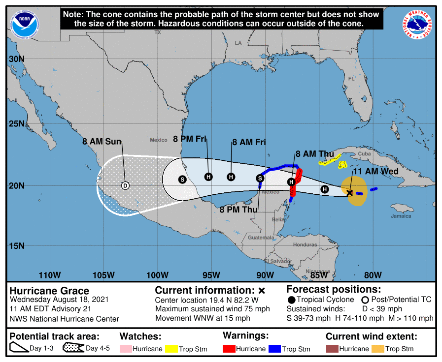
Hurricane Grace is expected to make landfall in the Yucatan Peninsula Thursday morning, and could intensify once it enters the Gulf of Mexico.
Hurricane Grace has maximum sustained winds of 75 mph, according to the 1 p.m. advisory from the National Hurricane Center.
Grace is is expected to reach the eastern Yucatan Peninsula early Thursday morning, and enter the western Gulf of Mexico Friday. Weakening is expected as it passes over the Yucatan Peninsula, but some restrengthening is likely as it moves into the Gulf.
Hurricane-force winds extend outward up to 25 miles from the center and tropical-storm-force winds extend outward up to 115 miles.
The storm is located 295 miles east of Tulum, Mexico, and is moving west-northwest at 15 mph. It is expected to continue a westward to west-northwestward movement for the next several days.
Cone of uncertainty: See the latest graphic from the NHC
Satellite images: See latest satellite image from NOAA, for a clearer picture of the storm’s size
Later Wednesday morning, Grace is expected to pass over the Cayman Islands, and the current track has the storm moving into Mexico early Saturday morning.

Latest data on Hurricane Grace
Here is the latest data on Hurricane Grace pulled from the National Hurricane Center’s latest advisory.
- Location: 295 miles east of Tulum, Mexico
- Maximum sustained winds: 75 mph
- Movement: West-northwest at 15 mph
- Pressure: 995 MB (millibars)
- When next advisory will be released: 4 p.m. CT