- One set of evacuation orders lifted in Caldwell County after wildfire contained
- 'We gutted every building' | Chimney Rock rebuilding after Hurricane Helene
- 'We gutted every building' | Chimney Rock rebuilding after Hurricane Helene
- Debris from Hurricane Helene provides fuel, complicates containment for spring wildfires
- David & Nicole Tepper increase Hurricane Helene relief commitment to $750k
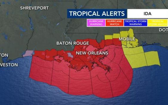
Ida to make landfall in Louisiana as Cat. 3 hurricane on 16th anniversary of Katrina
Ida was upgraded to a hurricane on Friday afternoon as it moved over warm waters near the Gulf states.
The storm is expected to be at or near major hurricane strength when it makes landfall near Louisiana late Sunday. That day also marks the 16th anniversary since Hurricane Katrina made landfall in the state.
Ida has been rapidly gaining strength as it moved over Cuba — winds increased from 35 mph to 75 mph in less than 24 hours. On Friday afternoon, President Biden issued a State of Emergency in advance of Ida’s expected impact.
Winds are expected to be as strong as 120 mph when Ida arrives on Louisiana’s coast. Forecasters say the storm is expected to bring significant inland flooding to the region.
Reports indicate the storm may be strong enough to top multiple levees defending towns and cities in the area. In response, the mayor of New Orleans called for everyone outside the levee system to evacuate before Ida hits Louisiana.
“Unfortunately, all of Louisiana’s coastline is currently in the forecast cone for Tropical Storm Ida, which is strengthening and could come ashore in Louisiana as a major hurricane as Gulf conditions are conducive for rapid intensification,” Gov. John Bel Edwards said.
“By Saturday evening, everyone should be in the location where they intend to ride out the storm.,” the governor added.
A hurricane watch was in effect for Cameron, Louisiana, to the Mississippi-Alabama border — including Lake Pontchartrain, Lake Maurepas and metropolitan New Orleans.
Ida will be the fourth hurricane to make landfall in the state since last August.

Model plots show the storm could take a right turn and head toward North Carolina. Our state could get rain from Ida early next week, but impacts are not expected to be severe.

Tropical moisture could interact with a boundary that’s up in Virginia, WRAL meteorologist Elizabeth Gardner said. Ida could affect communities in the mountains near Asheville and the northern part of the WRAL viewing area.
Two other systems are unlikely to affect the U.S. as they curve around an large area of high pressure centered in the far eastern Atlantic.

The peak of the Atlantic hurricane season is Sept. 10. Historically, mid-August through October is the most active period of the Atlantic season.