- Charlotte-based marketing agency announces $20,000 Creative Campaign Grant to help communities after Hurricane Helene
- Artists transform hurricane aftermath into hoop-inspired masterpieces at Charlotte exhibit
- NC's cost for Hurricane Helene damage is nearly $60 billion, state says
- State to develop drone program to better respond to disasters like Helene, Florence
- South Carolina residents face deadline to get storm debris out to the curb after Hurricane Helene
Ida, now a tropical storm, won't have major impact on NC

Ida was downgraded to a tropical storm Monday morning after making landfall along the Gulf Coast as a catastrophic Category 4 hurricane.
Ida battered Louisiana on Sunday and overnight, ripping roofs off homes and threatening flooding, and the storm will move up the Mississippi valley on Monday. Now that Ida’s winds are weakening, the main threat will be heavy rain.
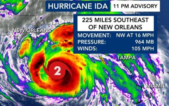
WRAL meteorologist Elizabeth Gardner said the storm’s winds are still dangerous but are now losing the potential to do that kind of damage as it moves away from Louisiana. Winds are now at 60 mph, a large decrease from the 11 p.m. advisory, which showed 75 mph winds.
“This is a weakening system but the flooding threat continues,” said WRAL meteorologist Peta Sheerwood. “This system is still moving slowly. Tornado watches remain in effect today for Louisiana, Mississippi, Alabama and Florida. More rain to come, upwards of 8 inches.”
Gardner said only the southwestern tip of North Carolina is likely to feel impacts from Ida on Wednesday as the storm passes the state.
Ida could be a depression by Monday night, Gardner said.
Ida was the fourth hurricane to make landfall in the state since last August.
The peak of the Atlantic hurricane season is Sept. 10. Historically, mid-August through October is the most active period of the Atlantic season.