- David & Nicole Tepper increase Hurricane Helene relief commitment to $750k
- David & Nicole Tepper increase Hurricane Helene relief commitment to $750k
- McDowell County wildfire spreads to 500 acres, evacuation orders in place
- Evacuations in Caldwell County due to wildfire
- Northwest Houston 'ghost neighborhood' caused by repeated flooding to become latest detention basin
What You Need To Know Ahead Of Tropical Storm Nicholas

Tropical Storm Nicholas is expected to make landfall on Texas’ Gulf Coast later Monday.
Texas Standard spoke with Eric Berger, a meteorologist and editor of Houston-based Space City Weather, who’s tracking the storm.
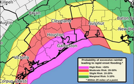
The threat for excessive Heavy Rain will continue across much of SE TX today. Updated guidance has the southern third of the area under a HIGH RISK for excessive rain as #TSNicholas approaches. #GLSwx #HOUwx #TXwx pic.twitter.com/s0QL23QMIB
— NWS Houston (@NWSHouston) September 13, 2021
Here’s what you need to know ahead of the storm:
– Nicholas is expected to make landfall somewhere between Corpus Christi and Matagorda Bay on the Texas Gulf Coast sometime Monday evening.
– It’s expected to make landfall as either a tropical storm or Category 1 hurricane.
– Residents in counties along the coast, as well as two to three counties inland from the coast, should prepare for the greatest effects of the storm.
– Coastal impacts will likely include: gusty winds and about 3-5 feet of storm surge.
– Inland impacts could include: flooding from rainfall. Berger compared Nicholas to last year’s Hurricane Beta, which dumped 10-15 inches of rain in some areas. He says Houstonians, in particular, should expect several inches of rain, which could lead to flooded bayous and even some homes.
– Other possible impacts: power outages.
So far, Berger says the storm models show Nicholas poses the greatest impact for flooding on Tuesday, and then it is expected to head toward East Texas and Louisiana by Wednesday. However, an unlikelier scenario is that the storm turns northward and stalls over Houston, which could mean significantly more rainfall and flooding there.
The number of Atlantic hurricanes this season is outpacing previous seasons. But Berger says the silver lining is that the season in Texas usually dies down by the end of September.
“If we can get through this storm, which is is really, you know, potentially pretty bad for the Texas coast and the Houston area, it does look like we’re going to be sliding into fall fairly soon,” he said. “This is probably the final significant threat our region faces this year.”