- Seven months after Hurricane Helene, Chimney Rock rebuilds with resilience
- Wildfire in New Jersey Pine Barrens expected to grow before it’s contained, officials say
- Storm damage forces recovery efforts in Lancaster, Chester counties
- Evacuation orders lifted as fast-moving New Jersey wildfire burns
- Heartbreak for NC resident as wildfire reduces lifetime home to ashes
Heavy rain expected in NC mountains & foothills, flash flooding possible

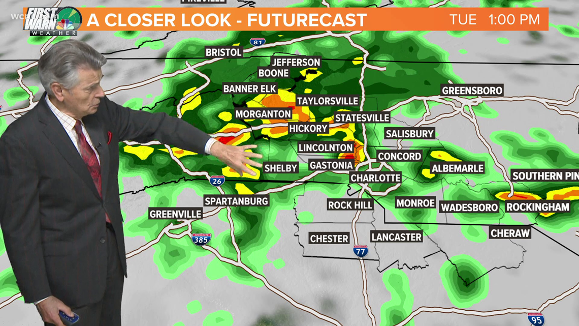
The mountains and foothills could see up to 4″ of rain Tuesday, with flash flooding possible in some areas, forecaster Larry Sprinkle said.
CHARLOTTE, N.C. — Tuesday will see heavy rain across parts of the Carolinas, with up to 4″ of rainfall possible in the North Carolina mountains, First Warn Forecaster Larry Sprinkle said.
A storm system moving in from the Atlantic Ocean will bring heavy downpours to some areas of South Carolina before reaching the Charlotte metro. From there, the rain will continue to move northwest with the highest totals expected in the High Country. Sprinkle said there is the potential for flash flooding in the mountains and foothills Tuesday afternoon.
“The major problem areas would be in the foothills and mountains,” Sprinkle said. “There could be a significant amount of rain from Taylorsville to Boone and Blowing Rock, all the way over to Morganton and Burke County, especially the mountains of Burke County.”
The first wave of showers will move into the Charlotte area during Tuesday’s morning commute. Sprinkle said it won’t be heavy but will be enough to get the roads wet and force people to use their windshield wipers. By 8 a.m., Sprinkle expects some heavier showers to move into the Piedmont of North Carolina.
“At 10 a.m., there will be heavy rain from Asheville, along Interstate 40 to Morganton and into the Charlotte metro area,” Sprinkle said.
The showers will dump rain on Charlotte until around 6 p.m. Anyone with travel plans along Interstate 40, Interstate 77, U.S. 421 and U.S. 321 should be aware of potentially dangerous conditions at times.
“Some areas could see over 2″ and 4″ around Boone,” Sprinkle said. “Anywhere from 1-2″ is a definite possibility between today and tomorrow.”
Wednesday brings the first day of fall but summer won’t go away quietly. Sprinkle said plenty of sunshine and highs around 80 degrees could increase the threat of afternoon storms.
This weekend will be pleasant with highs around 75 degrees in the Carolinas and Carolina blue skies.
Contact Larry Sprinkle at lsprinkle@wcnc.com and follow him on Facebook, Twitter and Instagram.
Wake Up Charlotte To Go is a daily news and weather podcast you can listen to so you can start your day with the team at Wake Up Charlotte.
SUBSCRIBE: Apple Podcasts || Spotify || Stitcher || TuneIn || Google Podcasts
All of WCNC Charlotte’s podcasts are free and available for both streaming and download. You can listen now on Android, iPhone, Amazon, and other internet-connected devices. Join us from North Carolina, South Carolina, or on the go anywhere.