- South and Midwest face potentially catastrophic rains and floods while reeling from tornadoes
- Deadly 2024 hurricanes prompt WMO to retire three names
- Body recovered in North Carolina identified as East TN man who has been missing ever since Hurricane Helene
- Report: Coastal flooding could threaten 1.4 million homes by midcentury
- Caught on camera | Tornado touches down in Missouri
The 2021 hurricane season alphabet could be completed this week

Three waves have a 50-80% chance to form into a tropical depression or tropical storm. Also tracking the fourth major hurricane of 2021.
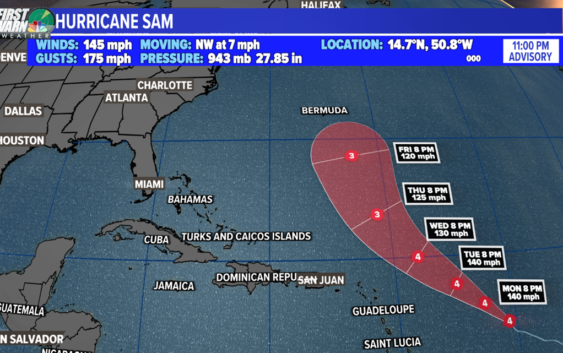
CHARLOTTE, N.C. — Hurricane Sam continues to maintain its major hurricane status in the Atlantic. Sam rapidly intensified to a major hurricane during the weekend. The fourth major hurricane of the season latest advisory shows maximum sustained winds of 125 mph as it moves to the northwest. Rapid intensification happened over the weekend but now it will maintain its status as a major hurricane (category 3 or greater) up until Bermuda. It will luckily pass safely east of Bermuda but the island could endure some heavy rain and storms from the outer bands.
Long-range forecast models indicate a strong trough of low pressure will keep the storm away from the United States east coast.
Other than Sam, there are three areas of interest to watch. A low pressure system associated with the remnants of Peter is located southeast of Bermuda. There is a small, limited potential for development over the next 5 days.
There are three waves that have a shot to be named. As mentioned in the tweet above, there are only two names that are left on the seasons list. This season will go down as the 3rd most active season on record. It is far from the strongest but the number of storms has already made 2021 historic.
There are two tropical disturbances in the central-east Atlantic Ocean. The first is a broad area of low pressure moving westward. Slow, gradual development (80%) is possible over the next few days.
Lastly, we have a new tropical wave expected to move off the west coast of Africa on Monday. Right now, the National Hurricane Center is giving it a 80% chance of development.
The leftovers from Peter is still turning in the Atlantic and has a shot to form into a depression at least.
NOTE: If you are wondering when Teresa formed? It happened over the weekend and turned post-tropical within 24 hours.
Ever since Ida, all storms have formed out in the Atlantic and most have been short lived. Larry and Sam were the 3rd and 4th major hurricanes of the season.