- Cast of Scandal reunites to show support for western North Carolina after Hurricane Helene
- Tropical Storm Sara threatens to bring flash floods and mudslides to Central America
- Hurricane-stricken Tampa Bay Rays to play 2025 season at Yankees' spring training field in Tampa
- Utah scores 3 goals in 2 1/2 minutes in 3rd, Vejmelka has 49 saves in 4-1 win over Hurricanes
- Driver dies after crashing off hurricane-damaged highway in North Carolina
Flash Flood Warning in effect for San Antonio area as storms move across South Texas | Track the rain

Parts of South Texas may get more than four inches of rain, which could lead to flooding.
SAN ANTONIO — A Flash Flood Warning is in effect for parts of Bexar and Comal counties, including San Antonio, until 1 a.m. Thursday as storms caused by Tropical Depression Pamela continue to push through South Texas.
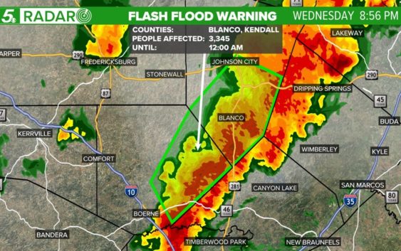
A Flash Flood Warning has been issued for parts of Kendall and Blanco counties where an estimated three inches of rain has fallen and two additional inches are possible. This warning will remain in effect until midnight.
A Severe Thunderstorm Warning for portions of Gillespie, Kerr and Bandera counties expired at 6:30 p.m. Previously, a Severe Thunderstorm Warning issued for parts of Uvalde, Real, Bandera and Kerr counties expired at 5:45 p.m. And a Tornado Warning previously in place for Blanco, Comal and Kendall counties has expired.
Heavy rain arrived in parts of South Texas Wednesday afternoon and is continuing through this evening with a Flash Flood Watch in place until 7 p.m. on Thursday.
While the Flash Flood Watch will continue until late tomorrow afternoon, the heaviest of the rain is forecast for South Texas from 8 p.m. Wednesday through 2 a.m. on Thursday.
The heaviest rain in San Antonio and along the I-35 corridor will likely occur between 9 p.m. and 11 p.m.
All of the rain is being driven by deep tropical moisture surging over the region from Mexico as Tropical Depression Pamela weakens and the remnants of the system move over South Texas.
Any rain that does occur tonight will likely be very heavy due to the amount of moisture within the profile of the atmosphere.
Expect lingering showers and storms during the morning on Thursday, but drier conditions will move in for the afternoon.
For the seven-day rainfall forecast, we are expecting four to six inches of rain in parts of the Texas Hill Country with other parts of the region experiencing one to three inches of rain. Nearly all of this rainfall is forecast to occur within the next 24-hours.
After Thursday, we will have the possibility of one more brief period of rain for Friday as a cold front sweeps across the Lone Star State.
Drier, cooler air will move in behind the front and temperatures will be in the 40s to 50s for lows and 70s for highs under a mostly clear sky throughout the weekend and into the early part of next week.