- Fake job seekers are flooding the market, thanks to AI
- One set of evacuation orders lifted in Caldwell County after wildfire contained
- 'We gutted every building' | Chimney Rock rebuilding after Hurricane Helene
- 'We gutted every building' | Chimney Rock rebuilding after Hurricane Helene
- Debris from Hurricane Helene provides fuel, complicates containment for spring wildfires
Severe weather, wind advisory and near-record heat in Monday's forecast
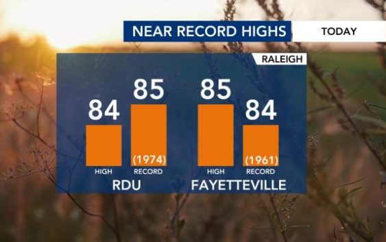
Raleigh, N.C. — With a high of 84 degrees expected in Raleigh, we’ll see near-record heat today.
According to WRAL meteorologist Elizabeth Gardner, the record high of 85 degrees was set back in 1974. It’s possible we could match or beat that record by Monday afternoon.
Temperatures were already in the upper 60s at 5 a.m.

At 10 a.m., a wind advisory goes into effect for counties from the Triangle northward, including Wake, Chatham, Durham, Edgecombe, Franklin, Granville, Halifax, Nash, Orange, Vance, Warren and Wilson. The advisory expires at 7 p.m., so wind gusts up to 40 mph will be possible throughout the entire day.

Monday will be a dry day, but clouds will build through the afternoon.
There is a Level 1 risk for severe storms Monday night, mainly after 8 p.m. and north and west of the Triangle, according to Gardner. In the Triangle, the risk for bad storms is relatively low.

Damaging wind gusts and heavy rain will be the biggest risks. The storms should begin to clear after midnight.
Tuesday will be a mostly dry, cooler day, with a high in the low to mid 60s. Rain will arrive overnight and fall for most of Wednesday, Gardner said, calling it an “all-day rain.” Wednesday will be cooler, with highs in the 50s and an 80% chance for rain most of the day.
Showers will also be possible Thursday, Friday and Saturday. According to Gardner, over 2 inches of rain could fall over the next seven days, but it will be spread out.
Right now, the weekend looks mild, with highs in the mid to upper 50s. Saturday will be wet, but rain is not expected on Sunday.
