- Wildfires persist across Carolinas amid windy, dry conditions
- York County crews help battle South Carolina wildfires
- Crews battle wildfires in North and South Carolina amid dry conditions and gusty winds
- As wildfires grip South Carolina, governor warns: Burn and you’ll go to jail
- Sebastian Aho's OT goal lifts Hurricanes past Flames 2-1
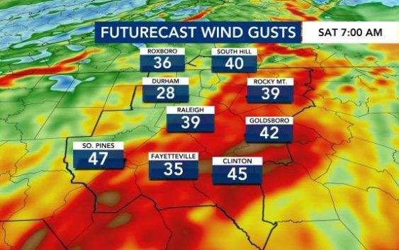
Lightning, localized flooding: Band of strong storms moves across central NC
Raleigh, N.C. — A line of severe thunderstorms was moving into central and eastern North Carolina early Saturday morning. Heavy rain and lightning were possible as the band of storms moved east, from the Triad to the coast.
Areas in the northwest part of the Triangle, including parts of Chapel Hill, Hillsborough and Durham, are under a Level 1 risk. Raleigh, Fayetteville and communities northeast of Raleigh are under a Level 2 risk. Almost everyone along and east of Interstate 95 is covered by the Level 3 risk for severe weather, said WRAL meteorologist Elizabeth Gardner.

The line of thunderstorms should move into the Triangle around 4 a.m. and storms are expected to last until 10 a.m., with the best chance of severe weather being before 7 a.m.
Communities south and east of Wake County are more likely to see tornadoes and hail as warm air is fueling the thunderstorm. In the areas under Level 1 and Level 2 risks, damaging winds and a brief tornado will be the main threats. Areas under a Level 3 risk have the possibility for stronger tornadoes.
In Raleigh, there’s a chance that damaging wing gusts could bring down trees. Winds were gusting to 25 mph in Raleigh and 36 mph in Fayetteville at around 5 a.m.
Even after storms move out of the Triangle, wind gusts are expected to reach more than 50 mph on Saturday afternoon.
Tornado watches have been issued for counties in southern Georgia, but that threat is not expected to reach North Carolina Saturday morning.
“While instability appears low, we will continue to watch to see if a severe watch is issued. However, that seems unlikely,” said WRAL meteorologist Peta Sheerwood.

A line of storms formed from Person County into Chatham County on Saturday morning, and so far, there have been no severe thunderstorm warnings associated with that band of rain.
Some weekend events and festivals may be canceled or postponed due to the severe weather expected Saturday morning. Cary already moved its Arbor Day celebration of spring from Saturday to Sunday, but the largely-attended St. Patrick’s Day Festival in downtown Raleigh will go on rain or shine due to the amount of planning involved, organizers told WRAL News.

The storms are expected to move out of the area before noon on Saturday, then colder air will surge in.
“Arctic air is going to move through. We have some cold air behind this very strong front,” according to WRAL meteorologist Aimee Wilmoth.

Temperatures will continue to fall throughout the day. As of 4 a.m. on Saturday morning, it was 56 degrees outside. By the afternoon, temperatures will drop to the upper 30s and overnight it will be in the low 20s.
Sunday morning is expected to be the coldest March morning the Triangle has seen since 2015.
There is a chance for a rain and snow mix along the North Carolina-Tennessee border.
Sunday will be a frigid start with temperatures in the lower to mid 20s. Temperatures could
Some people hate Daylight Saving Time while others love it. It may mess with your sleep schedule, but beginning Sunday, the sun will set an hour later, closer to 7:30 p.m. than 6:30 p.m. By the summer solstice, the sun won’t set until after 8:30 p.m.

While temperatures will start off in the teens and 20s, temperatures will rebound for Sunday afternoon, with highs in the upper 40s and lower 50s and plenty of sunshine expected.
