- Cast of Scandal reunites to show support for western North Carolina after Hurricane Helene
- Tropical Storm Sara threatens to bring flash floods and mudslides to Central America
- Hurricane-stricken Tampa Bay Rays to play 2025 season at Yankees' spring training field in Tampa
- Utah scores 3 goals in 2 1/2 minutes in 3rd, Vejmelka has 49 saves in 4-1 win over Hurricanes
- Driver dies after crashing off hurricane-damaged highway in North Carolina
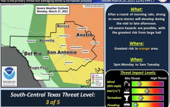
Tornadoes, hail, damaging winds possible in San Antonio area for Monday

As spring break ends, the start of the school and work week is bringing a lot of noise in terms of weather, including the chance of large hail and thunderstorms Monday.
The National Weather Service provided an update Sunday afternoon on the severe weather expected for the San Antonio area. Strong to severe thunderstorms are expected near or just west of US-281 mid-afternoon on Monday between 1 p.m. and 4 p.m.
The Hill Country could experience severe weather through 6 p.m. Monday at the latest. The I-35 corridor’s timing of severe weather is expected between 3 p.m. and 8 p.m. These times could change and if you’re going to be out and about, use caution.
Isolated areas could see up to 2 inches of rain. Because it’s been so dry, flooding is not expected, according to the NWS.
As storms move east, they could strengthen and produce large hail up to 2 inches in diameter. Damaging wind gusts of up to 60 miles per hour are possible. The NWS reports the risk for tornadoes will increase as the storm moves. Strong EF-2 tornadoes can’t be ruled out, according to the agency.
Coastal Plains counties could see a second round of storms after midnight Monday.
There are also more concerns for critical fire weather conditions west of Kerrville to Dilley. A Red Flag Warning could be issued again for some of those areas.
The National Weather Service is forecasting possible tornadoes in the area as storms move out of the region.
Courtesy of NWS