- Austin is at a 'potentially historic' risk of wildfires Tuesday. Here's how to prepare.
- South Carolina's governor declares State of Emergency as massive wildfire grows to 1,600 acres
- Staying weather alert: How to find your safe place during severe weather
- Wildfires persist across Carolinas amid windy, dry conditions
- York County crews help battle South Carolina wildfires
Brad Panovich says severe weather is possible Thursday. Here's the timing
Charlotte will likely see heavy rain and thunderstorms, with the threat of damaging winds and severe weather Thursday.
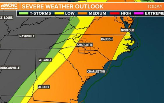
CHARLOTTE, N.C. — The Charlotte area will be at risk for severe weather Thursday afternoon as a line of storms moves across the Carolinas, chief meteorologist Brad Panovich said.
Panovich says the first wave of rain, which started around 8 a.m., will be mostly light to moderate rain. The threat for strong storms will come Thursday afternoon when the back edge moves through during the warmest point of the day.
Panovich said the severe weather outlook appears to show the mountains and foothills being mostly out of the woods for severe weather. Areas along Interstate 77 will likely be the dividing line for where the storms really get cranking.
“From Charlotte east, this is the area we’ll watch this afternoon,” Panovich said.
Areas at risk for severe weather Thursday include Albemarle, Charlotte, Concord, Gastonia, Hickory, Huntersville, Lincolnton, Monroe, Mooresville, Salisbury, Shelby, Statesville, Taylorsville and Waxhaw in North Carolina. South Carolina cities and towns in the medium risk include Chester, Fort Mill, Indian Land, Lancaster, Rock Hill and York.
Damaging winds the biggest threat
Rain moved in by 8 a.m. and those showers will last through midday. Panovich said the afternoon could see stronger storms with a primary threat of damaging winds. Thursday will be extremely windy, with gusts up to 40 mph possible during the storms.
“Our primary threat is still damaging straight-line winds,” Panovich said. “Overall, the wind risk is obviously, by far, the highest of all.”
The wind toppled a tree onto power lines along Providence Road in south Charlotte Thursday morning. At one point, hundreds of Duke Energy customers were without power. Crews were able to quickly restore power but the road was blocked until just before 9 a.m.
The timing
Panovich said the best timeframe for severe weather will likely be from around noon to 2 p.m. By 4 p.m., the trailing edge of storms will be moving through with a threat of strong storms. Eastern North Carolina could see some supercells by 7 p.m. and into Thursday night.
“If it’s going to happen, it’s going to happen this afternoon as the front pushes off the east,” Panovich said.
Panovich said the convective available potential energy — known as CAPE, or “thunderstorm fuel” — will build up in the middle of the day.
“You can see it does build a little towards the middle of the day,” Panovich explained. “And so, at 3 o’clock, there is some energy. This is that thunderstorm fuel, there is some energy there for these storms to get a little stronger as we go into the afternoon hours.”
Other threats
Wind: The No. 1 threat would be severe thunderstorms with gusty winds. These winds could occasionally gust over 50-60 mph, causing spotty damage and downed trees.
Tornado: There will be some spin to the atmosphere and there is a chance for a spin-up tornado but the treats are very low at this time. The Storm Prediction Center has a 2% chance for tornadoes in the areas north and south we mentioned previously in the article (in orange).
Hail: Currently this threat is the lowest severe parameter for the area.
Flooding: Any thunderstorm system has a chance to bring some localized and urban flooding, so the threat is there but most rain totals will range from a half-inch to 1.5 inches. This will all come within a six-hour period, which will lead to some significant ponding in areas. It wouldn’t be unheard of to see some isolated reports of 2 inches of rain, especially in the North Carolina mountains.